Well, you can more or less thank the teleconnections for all the latest mild and rainy winter weather in the United States. The NAO has been positive, the AO has been positive, and the PNA has been positive. Where do you want these teleconnections for the cold and the snow in the Northeast? You want the NAO to be negative, the AO to be negative, and the PNA to be positive. So, the only teleconnection that has been cooperating, is the PNA. It's been solidly positive. Well... A flip is about to take place... It's one that makes me happy and upset.
The latest teleconnections (which I cannot post because I'm on vacation time!) look interesting. FINALLY we see the NAO go towards neutral or negative and the AO go towards neutral or negative! Good news, right?! Wrong. Normally I would be happy with this, BUT now we have to worry about the PNA. After having the PNA being the only one supporting snowy and cold weather in the Northeast, it too decides to go negative. Something that is not supportive of cold and snowy weather in the Northeast. So what happens now? Well we probably see blocking set up, and maybe even have some good storms set up along the east coast and Northeast, but I'm not sure we'll have support from the temperatures. If the AO really decides to go negative, I will be happier and then maybe the PNA won't be such a concern like it is right now for me. The AO usually supports very cold weather. But the negative PNA often is a signal for warmer weather, so it will be a battle between those two. We'll have to see who wins...
As for the MJO, I know people were starting to get excited about it going into octets 8, 1, and 2, but that no longer looks to be the case. There is still time for change, but right now I'm not very pleased with it. Rather then going into the correct octets, we see the MJO head into octet 6 (already partially in 6) and then briefly move into 7, before moving into the COD. Not a very good place to support a negative NAO. And after that? It goes right back into octet 4, and maybe even back into 5. But again, thats only if all of this verifies. There is still plenty of time for the MJO to shift about, maybe going into more favorable octets... Only time will tell though...
Right now we are at a state of battles between all these different variables. It will be very interesting to see which one of them will win out, and right now I really do not know. My hope is that we see the MJO do a flip in the COD and head back into octets 8, 1, 2, or even 3, OR we don't see it go into the COD at all, and it heads straight into 8, 1, 2, or 3. It would also be nice to see the PNA stay positive, but right now a lot of models agree we see it go negative. Trust me, I want the cold and snow as much as everyone reading this, but until I see things head more favorable for the cold and snowy weather, we need to continue watching and waiting. It will come sooner or later, it's just a matter of when!
-Scott Pecoriello
Saturday, December 31, 2011
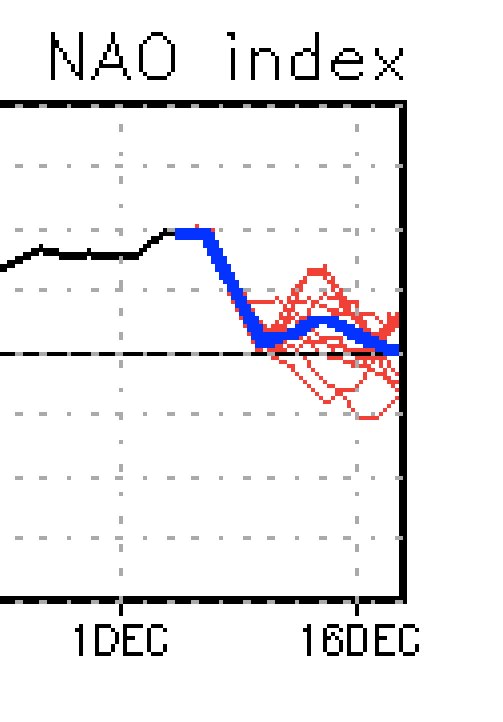
The terrible teleconnections
Thursday, December 29, 2011
Will it ever snow?!
Good morning folks! Another tough night of watching model runs. The last few runs of the OP models have shown very few storms, but plenty of cold air, which is often a killer for snow lovers. Better then warmth though... right?
The big question on everyones mind is, when is it going to snow?! Unfortunately I don't think anyone has an answer to that question at this point. So far November and December have been bleak. Shots of cold and warm weather, but neither sustained. A very frustrating pattern where the storms arrive just in time for the warm air to be in place, thus the lack of snow. Why is this? Well we can thank a lot of variables. Our teleconnections have been absolutely horrendous, with the exception of the PNA. Nothing but positive readings on the AO and NAO. Will that change though? What will it take to shoot that NAO down to some good negative readings? Well, I guess we'll discuss the MJO.
I am more pleased with the MJO then I have been recently. Still not happy, but not angry anymore. The MJO seems to have been endlessly wondering in octets 4 and 5. Octets that are VERY bad for the cold and snow here in the Northeastern United States. Where do they seem to be heading now? Well according to a lot of our models, the MJO is heading into octets 6 and 7. That's for sure right now. Better for snow? Maybe, but still not good. The question after that is, do we see the MJO go into octets 8 and then 1 and 2 (very good for the cold and snow). Right now it is unclear in my opinion. We have seen models try and show that happening, but I am not sold on it like others are. I remain skeptical. All I will say though, is that if you are a snow lover you better be hoping that the MJO heads into octets 8, 1, and 2, because that will influence our teleconnections and eventually our entire pattern. Hopefully that will become more clear over the next few days.
Just a quick reminder for those who want to make a comment. If you don't have something respectful or nice to say about this blog, then please just refrain from saying it completely. Just a few bad comments on here lately. To the people that continue to be respectful and support me thank you very much! The snow will come soon!
That's it for now. Very short update this morning from the beach in Turks and Caicos! Right now it is nothing but sunshine with temperatures well into the mid 80's. Anyways enjoy the weather where you are, and hopefully we'll see some changes soon for those of you who want some! Have a great day!
-Scott Pecoriello
Wednesday, December 28, 2011
Change will come with time!
Good morning everyone! Rough night last night, huh? Well, I warned people that this potential storm system that was very imminent on the 12z models, had about a 10% chance of staying on the 0z models... And what do you know... They weren't there! That doesn't mean much though. I know I sound like a broken record, but until people get the idea, I will continue to nail this into peoples heads. Remember CAT. Consistency, Agreement, and Trends. That should always help us with the models. Let's take the storm during the first week of January for example. Do we have consistency on the models? Very little. Do the model agree with each other? Not really. Are we seeing the storm trend in one direction or another? Not really. Instead it jumps from solution to solution, which is a sign this storm is very long range, and the models are struggling with it. What are we currently seeing? Just potential. The 0z's have almost completely gotten rid of the storm, but that is not to say it will not appear again. The models show a decent setup over the first week of January. The cold air is there, and so is an ok pattern. Not ideal, but it can support a storm.
The 12z GFS recently came out, and the moral of the story is... Cold! Something I posted about a few days ago on my Facebook page, but no one seemed to take seriously. In fact, I said "The coldest air so far this season will stream into the Northeast during the first week of January". That looks to be on track more than ever right now. The 12z GFS basically shows the pattern changing. We'll need to apply CAT to this soon though, because right now, although the GFS has been hinting at a change for a while now, it is just one run... Now we need a storm...
Regardless of the storm, my biggest concern is this pattern. I am done trying to pinpoint when this pattern change will occur, since I've discovered no one can. I remember hearing back in November and December that the pattern would change late November, and then I remember hearing even professional meteorologists talking about a change in the middle of December. I read multiple times the the snowiest part of the season for NYC would be between December 15th and December 25th. Until all of us, as a weather community, can figure out exactly how to forecast these pattern changes better, they're not worth trying to pinpoint. With that said though, that does not mean we cannot discuss what things will cause a pattern change, and give rough time periods. That's exactly what I plan to do.
We'll start with a popular subject. The teleconnections! They look just OK. Nothing too good, nothing too bad. I like to apply CAT to these too, just in order to determine how seriously we should be taking these. Let's start with the NAO...
CAT: Has recently become much more consistent, but continues to be VERY frustrating. After following this teleconnection for a while now, I have learned a lot about it. When it reaches its peak (fairly positive) the models show it going negative in the long range. Then as we get closer to that actual date, and the NAO does try and take a dip, the forecast shifts and shows it going briefly positive again, but still going negative in the long range. Then once it reaches another peak, the cycle starts over. Until we can break that, I really can't say the NAO is going neutral or negative. I want to watch it over the next 2-3 days, but right now it looks like it is on the exact track that I listed above, so not great news. Nonetheless, who really knows. It is showing negative in the about a week or two, so as long as it continues showing that, we're good.
The AO...
CAT: The AO has always been a mess, at least in the post few months, and continues to be. Not too much to say here other then do not trust the AO past 48 hours out. Something interesting to note though, is that it has not been showing the AO going very positive again. More neutral and even negative readings to come, if the current AO verifies in the medium and long range. But again, not to be trusted past 48 hours out.
The PNA...
CAT: Favorite of the teleconnections! Very consistent in it's forecast and doesn't change much from day to day like the NAO and AO do. It is also favorable for cold and snow in the east, but can't do that without the NAO and AO going negative. That's where our problem is. Nonetheless, it looks like the PNA will continue to stay with positive readings.
Another great subject to bring up right now is the MJO. Hasn't been in our favor lately, but the latest forecasts call for us to move into more favorable octets that call for cold and snow in the east. The MJO is often known for driving the pattern, and even affecting the teleconnections, so this is a big one to watch. The fact that it is heading into a favorable direction is BIG though. This may just be one of the reasons we keep seeing the NAO show negative in the long range. Now that we're seeing a more favorable MJO, we may soon see the -NAO become more of a reality. I'll continue watching this over the next several days.
And where would we all be without... The Stratospheric warming! Something I have discussed on multiple occasions. Delayed initially, we are now really starting to see some effects of the warming in our stratosphere. All of the above actually. Remember the "Domino effect" I posted about so many times on my Facebook page? Well we're in the middle of the effect now, and it all started with the Stratospheric warming... But I think we all know where it ends... A cold and snowy Northeast. The question isn't does this actually come to fruition, rather it's, when does this all come to fruition. Again, I don't want to pinpoint time frames, BUT I would say in the next week or two. We'll have to see! Things are looking up folks!
-Scott Pecoriello
Monday, December 26, 2011
Winter update... Winter is still coming!
*Excuse my lack of pictures! This was done on my Ipad, so it wasn't easy!*
Good afternoon everyone, I've decided to do a brief update on my winter forecast since well... We haven't seen much of a winter yet! I know this is concerning a lot of you, and that you're quickly giving up on this winter. That should not be the case, and you should know that I am not "giving up" on this winter, nor am I making any changes to my current winter forecast, which can be found in a previous blog post below.
Some of you folks just have to wake up, and take a look at the Calendar. I know that is something you're tired of hearing, but there are those of you who seem to have there mind set to March, so I think you just need to take a moment and realize it is December 26th. Yes, I know a year ago today was the boxing day blizzard of 2010, but the chances of us having another major blizzard around that time, a year later is very slim. It would be a miracle to have two years in a row of blizzards at the end of December. This boxing day blizzard of 2010 seems to be just another reason to say "winter is clearly over, because look, last year at this time we were seeing a blizzard!". That's just something you cannot say, and means little regarding our upcoming winter. A third reason as to why some of you have the "winter fever", is because you're snow spoiled! The last 3 years have been incredible in terms of snow and cold weather. While I do expect that again at some point this winter, it doesn't have to be as extreme. The "winter fever" list goes on and on, from trusting long range models to trusting teleconnection forecasts more than 48 hours out. A cure must be found! And I have faith it will... Hopefully this blog update will be the first treatment, but the to get rid of the disease completely, we just need some snow! And trust me folks, that shouldn't be hard as we enter the new year of 2012.
My current forecast for the Northeast for January is generally seasonable. The first week or two will be the trickiest and will determine what the rest of January, and possibly the rest of the winter season, turns out to be. If we see a colder and snowier first week of January, then you can expect more cold and snow as we head into the mid and latter portions of January. Right on into February and March as well. I don't see one week of cold and snow, and that's it. If it is particularly cold and snowy in the first week (week and a half if you must) of January, then that (in my opinion) sets us up for a cold and snowy rest of the winter. Now, if we see the opposite, a warmer and wetter first week or week and a half of January, then you can expect seasonable to above average temperatures with below average snowfall for the rest of January. As for February, I will still expect cold and snow, but not as extreme as what I would call for if the first week of January was cold and snowy. See what I'm doing? So we'll have to see if this little trick that I've created to forecast the rest of the winter, actually works out. It sure will be interesting!
Let's take a look at last year, shall we? I want to say 75% (maybe more) of the cold and snow that we saw, occurred in late December and January. That's a little more than a month, maybe not even. Think about that. If it only took 1 month to give New York City over 60 inches of snow, then why can't we see it happen again, just later on? The answer is, we can! Just historically, it is rare. But hey, if we take a look at the past three or four winters, I think we can say we've made some history of our own, so that is no worry to me.
But yes, historically, a cold and snowy winter is NOT in our favor. At all, actually. Let's take New York City for example. Most the years that NYC has seen less than 3 inches of snow in the month of December, they have seen seasonal snowfall averages well below what they should be. Is NYC going to see 3 or more inches of snow before December ends? I give that about a 20% chance of happening. So does this automatically mean NYC will see snowfall average well below average this winter? No! Of course not! Some meteorologists who are very into historical weather may say so, but like I said above... We've proven history wrong MANY times over the past 3-5 years. The number of extreme and historical events that we have seen here in the Northeast and around the country, continue to grow, which is why history is not a concern for me, at the moment. Again, these are current thoughts. We'll see where I am on December 8th.
Well that's it for now folks, and I hope you've enjoyed this short update. Remember, any questions or concerns that you have can be asked right on here in the comments below, on my Facebook page, "Wild about Weather", or on my twitter, @wildabtweather! Enjoy these next few days of warmer weather along the east coast, and some snow inland, because the change is not far away!
-Scott Pecoriello
Tuesday, December 20, 2011
December 20th - January 1st Winter weather update
Tonight expect scattered showers across the Northeast, with the potential for more wintry precipitation as you head further inland and higher in elevation. It's possible we get some light accumulations well north, as well as some icing issues. Right now though, I don't see this being a major issue. Tomorrow mild temperatures will dominate the Northeast as we see some heavier batches of rain move into the area. That storm will move through rather quickly, but as it exits later tomorrow night, the next storm will be right on the horizon.

This one has recently become interesting. My gut feeling is it is all rain for coastal sections, with a mix or some snow inland. Not a big deal. But, some models are beginning to disagree. A few models have began trending colder with this particular storm on Friday, but not by a lot. The most notable right now is the NAM. The 0z run has trended much colder with the 850's, but remains warm at the surface.
 Nonetheless, the NAM shows snow being able to fall all the way down very close to NYC, with the potential for even accumulating snow 40-60 miles north. Whether the storm is warmer or colder, I do not expect anything too significant out of this. Maybe just a few wet snow showers to let people know winter is here, with light accumulation over higher terrain.
  I want to keep an eye on this storm though, since it seems like it may have a trick or two up its sleeve.
And now the storm that I have been talking about for almost a week now, our Christmas snowstorm. I have said again and again, I am sticking to my guns with this one. And I still am. This is, until I see reason to change my forecast. I understand that we currently have a +NAO and that the GFS has a storm that forms hundreds of miles to the south of the Northeast and goes right out to sea. What I want everyone else to understand though, is that models are an absolute mess right now. I can go through a list of models right now and find everything from a rainstorm for most areas in the Northeast, to a snowstorm for most of the Northeast, to no storm for most of the Northeast. The models are a joke right now, which is why I do not want to change my current forecast.
REMEMBER, we look for three things. Trends, consistency, and agreement. Right now, trends are a mess because they are so extreme back and fourth, so it is almost pointless looking for them. Consistency is a mess on most models right now, with the exception of the Euro, which gives me reason to believe the Euro has the best idea on this storm right now. What does the Euro show? Right now we see a good snowstorm for areas not too far north and west of I-95 and the big cities. Even those areas get in on the action.
 The Euro is VERY similar to my current map. Another reason I do not want to make any immediate changes to my map right now. And finally agreement... Hopefully from the paragraph before this one, you can tell how much agreement we have between models right now... None.
So I'm just hugging the Euro right now... right? Just because it is the snowiest solution? No. Not in the least. I'm currently going with the Euro for a few reasons. One, it is the only model right now that I can see with decent consistency. Two, the Euro is entering its prime forecasting range... This is typically where it is most accurate. Lastly, the Euro has done pretty well so far this season, especially if we try and compare it to the other models.
GFS? Great Failure System? Looks like it right now. I believe yesterday we watched the GFS show a rainstorm on Christmas, and now we are looking at a storm that barely develops and scoots on out to sea. Not a good choice right now folks.
12z GFS

18z GFS

Other models? I've been looking over a few other models like the CMC, Ukie, DGEX, etc., but again, lots of issues with our three big points and those models right now. That's why I will stay away from them for the most part until we start seeing some trends, consistency, and agreement.
We move on to our very final week of December. A storm is lurking folks. Very little detail on the storm right now, but the setup continues to look decent. It would not surprise me if we saw a good snowstorm to close December out.
18z GFS

A lot up in the air right now folks, and like always, I'll be sure to keep everyone updated. Things are really starting to crank up in activity as we head into the 2011-2012 winter season. Just because we may be seeing sloppy storms now, doesn't mean we continue seeing sloppy storms in the middle of January and February. Now get a good nights rest, and enjoy the upcoming storms! Also, a very happy Hanukkah to anyone celebrating tonight!
-Scott P.
Sunday, December 11, 2011
Official 2011-2012 winter weather forecast

For some, winter has gotten off to a slow and boring start, while for others, they've already seen enough of the white stuff. Overall, I think we can agree the Northeast is ready to get cranking on winter. We got off to a historically fast start, with a category 4 snowstorm in October that dropped almost 3 feet of snow over parts of western MA. With that, the only thought on everyones mind was winter is here! Wrong. Shortly after we warmed right back up and had highs back in the 60's and even 70's for quite a while. The talk of snow and cold quickly dwindled as people assumed this was just a short break before we'd get right back into the snow and cold. Wrong. Weeks, and eventually months, passed with a generally mild Northeast. Actually seasonable until we got into November. From time to time we would see interior events, but nothing major or widespread. Not only was the talk of an early starting winter over, but a new talk rose. The talk of a mild and snowless winter. Now were these folks pampered with snow to such an extent that they thought winter was already over... In November? Or were they just wishing for a nice and mild winter, and finding any possible backups they could to prove this winter would be a dud? It might be the first answer, it might be the second... The point is, both of them are wrong. The October snowstorm is what I like to call "bonus snow", or a "freak event". In my opinion, irrelevant to what the rest of the winter has in store for us. But still, others will disagree, and continue with there claims of a mild winter ahead...

Now that we are into the month of December, things have changed. The mood itself is one that is ready for the cold and snow. People wondering why it hasn't come to their areas yet. It is just a matter of the pattern folks. For the past 3, 4, even 5 weeks we have been seeing a rather flat and fast moving pattern that brings quick shots of cold, and periods of warmth with storms. Some might actually call it a typical La Nina pattern, which happens to be the pattern we are currently in.

I had been calling for this pattern to end on December 10th. That was yesterday... Any change? I explained this rather quickly on my page yesterday, but to sum it up once again, yes, there was a change. We are no longer seeing long periods of warmth and rain with quick shots of cold. Notice last night the coldest air of the season seeped down into the Northeast bringing teens and 20's to the I-95 suburbs, and even to the big cities themselves. Tonight will be much of the same. Highs today didn't even hit 40 degrees in the big apple, something I called for about a week ago. We will see the highs remain cold and seasonable through this week, with a shot of warmth at the end of the week, and then back to cold and seasonable by next weekend. It doesn't take a genius, or a meteorologist, to figure out what the change was. Rather then seeing warm weather with short periods of cold weather, we are now seeing cold weather with short period of warm weather. I expect that to become more dramatic as we head through the month of December.
But what about a true pattern change? A change that would finally bring blockbuster snowstorms up the East Coast and leave the major I-95 cities with big snow totals. When are we going to see those? Well, if you ask any of the major forecasting stations, they'll tell you it short and simple. Those areas may see a storm or two that drops decent amounts on the big cities, but nothing exciting. It's a typical La Nina, so we stay relatively warm across the big cities, and see a lot of rainstorms throughout most of the winter. WRONG. There is just no support for that. First off, it's more complicated then a typical la nina. We have an east based la nina. Want to know another year we had an east based La Nina? 1995/1996. Hopefully we all remember how that winter turned out for the Northeast. I think we'll just say the theme was snow. Interesting to note though, the season wasn't especially cold. Cold enough to support snow though, obviously. The point is, this particular type of La Nina can, and often does, support snowy weather... Something that these major forecasting stations seem to not want to mention.
Accuweather's winter forecast:

Famers Almanac winter forecast:

Another thing about these major forecasting stations... What happened to the MJO, the QBO, the NAO, the PNA, the AO? Where'd they all go? The only one of these mentioned on here is the NAO, or the Northern Atlantic Oscillation. A very key component to any winter, but especially a La Nina winter. It can be the difference between a warm, wet, and rainy winter, and a cold, wet, and snowy winter. In the simplest terms possible, a -NAO will support cold and snow in the Northeast, while a +NAO will support a warm and often snowless Northeast. The NAO is nearly impossible to predict, even with our extremely high tech weather models that we have in modern times. The forecast only goes out 2 weeks, and is often wrong. So what do these major forecasting stations say about the NAO?...
 Again, short and simple. The NAO looks to remain POSITIVE throughout most of this winter season. Wait, how can they say that if the NAO is only forecasted 2 weeks out, doesn't winter go on for more than 2 weeks? And if it is so difficult to forecast the NAO, what makes them say that the NAO will remain positive this winter? Exactly. No one can say what the NAO will do beyond 2 weeks, if that. LUCKILY though, there are signs for when the NAO and AO (The AO is similar to the NAO in terms of negative and positive) will turn negative, and we are beginning to see those signs pop up... Boy would that be embarrassing for those folks...
Again, it is rather complicated, but sometimes meteorologists will use the temperatures in the stratosphere to determine what might end up happening here in the troposphere. Currently we are seeing temperatures in the stratosphere warm up which, with a negative QBO (like we currently have), will cause the stratosphere to expand and have a cooling effect on the troposphere This sets off a domino like effect. Now we begin seeing deep upper lows develop, and the negative QBO supports the NAO and AO to turn negative. Then we are in business for winter. Now whether you understood any of that or not, isn't so important. The point is that you understand this event is currently taking place, and supports a true pattern change to take place in about 2-3 weeks. Once that happens, now we can start talking about major blockbuster snowstorms back to back for the Northeast.
Now to the more exciting stuff... The forecast basically from now right into March... Presenting you the 2011-2012 official winter weather forecast!

Zone A:
Expect temperatures to remain right around normal, with shots of colder and warmer than normal temperatures. Overall though, I believe temperatures average out right around normal. Late January and into early February these regions may see some very cold shots, and I do see the potentially for 1 or 2 winter storms to take place in this region, with the exception of FL. Florida, while temperatures will become chilly, will most likely not be experiencing winter precipitation. Much of December and the first part of January, as well as towards the end of the winter season will feature temperatures at, or slightly above normal. The theme for this region though will be the dry weather. I expect this to be persistent through much of the winter.
Zone B:
Expect temperatures to average out at below normal. Sustained cold is a good bet for this region, as well as above normal snowfall. Although this region will not necessarily be the "target" for major winter storms, there is a good chance these areas see a lot of moderate snowfalls from systems that produce major snowfalls just to the north of this region. The number of storms seen though, is likely to add up to above normal snowfall. The coldest air will come through during January and February, with the potential for snow into March and April.
Zone C:
Expect average to below average snowfall in this region. Temperatures will likely average out slightly warmer than normal. This area is likely to get a good dose of rain, as the frozen precipitation remains mostly to the north. However, as we head into the heart of the winter season, I do expect one or two storms drop frozen precipitation all the way down into this region. Overall though, I would say you do not want to be in this region if you are looking for cold and snow.
Zone D:
The summary of zone D is cold and snowy. Expect moderately to exceptionally above average snowfall across the region, with the potential for numerous major snowfalls. This region will be where the heart of winter is. For western regions, the above average precipitation will result in higher elevations receiving a lot of snowfall. For the midwestern regions, blizzards may be common during February, and in the Northeast, Nor'easters and storms crossing the country may explode off the coast and send plenty of moisture back into interior sections, along with very cold air in place. Lake effect events will also become much more common and significant during month of January, but are likely to relax towards the middle of the winter. If your looking for a good winter... This is the place to go.
Zone E:
Ah... Zone E... A lot I can say about this zone. One, notice it covers the I-95 cities from DC to ME. A very heavily populated area, and one certainly full of weather nuts. I could probably rename Zone E is, "The battle Zone". This region will be very interesting during this winter season in my opinion. This is where I expect the rain/snow line to set up, but the question is, where EXACTLY will it set up? It is possible that the line sets up at the very western edge of this zone, and that areas on the western edge, and to the east, see a lot of slop. Rain mixing with snow, and then going back to rain, or just all rain. It is also very possible we see the line set up much further east, and we get basically all snow events west of that line which would include most of that region. If that were to happen, I might as well extend zone D into zone E. The most likely of all right now though, is we see the line switch back and fourth between this zone. Some storms the region receives mostly rain or a lot of mixing, and other storms the region receives a whopping snowstorm. The point is, a LOT is unknown about this region right now. I can see everything from below average snowfall to exceptionally above average snowfall. At this point I do not want to rule out anything, but I am leaning towards a rain/snow line setting up further east...
Zone F:
This region will be plain and simple. An average winter. Now an average winter does not mean a boring winter. Just expect generally average snowfall, temperatures and overall weather events. I do see the potential for a significant icing event for the northern half of this region, and potentially even the southern half. One significant snowfall event is also possible for sections away from the coast.
Zone G:
The region includes Alaska only. Temperatures will be well below normal, with at or below normal precipitation. Although some of the coldest air ever recorded has come through the region last month, the region can expect very cold air to return once again later this month
Zone H:
This region include Hawaii only. Expect an average winter season. Temperatures may be slightly above average later on in the season, and precipitation may also be slightly above average later on in the season.
Zone I:
Mild and very dry. Very warm temperatures will occur during January, with dry weather to accompany it. Snowfall for higher elevations is likely to be below normal.
Zone: J:
Shots of cold weather with shots of warmer weather as well. Snowfall will be at or slightly below average. Precipitation will be below normal through the beginning of the winter, with normal or above normal precipitation by the seasons end.
Zone K:
Shots of very cold weather. Precipitation will normal throughout most of the season, but towards the end of the season precipitation will be above average. Snowfall will be normal or slightly above normal by the seasons end.
Zone L:
This region will experience "extremes" more or less. Shots of very wet weather, then very dry weather, then very warm weather, then very cold weather. Probably a repetitive pattern. Overall though, I believe mountains will experience above normal snowfall.
Zone M:
Very wet. Precipitation will be above average, and higher elevations will experience snowfall totals well above average. I believe even regions closer to the coast have a shot at seeing some snow, as temperatures will be below normal throughout most of the winter season.
To end what probably seemed like an endless 2011-2012 winter weather forecast, I decided to draw up something that I think most of you will enjoy...
If you thought my overall winter weather forecast was bold, take a look at this... I know a lot of Northeastern weather nuts have been waiting for a map like this. I don't think you'll get a forecast this detailed anywhere else, which is why I do not want people going crazy over. This is strictly meant to give people a general idea of where their snow totals will end up!

So remember folks, no one, including myself, controls the weather. The winter is in the hands of mother nature, and what you have just seen and read is my prediction of what she holds in store, for the 2011-2012 winter season. I hope you all enjoyed, and whatever mother nature brings us, get ready for winter 2011-2012!
-Scott Pecoriello of Wild about Weather
Monday, December 5, 2011
Potential I-95 snowstorm
This is my current thinking for the storm later this week, and let me tell you something... It will catch a lot of people off guard. Yes it is December 5th but if we take a review of the past few weeks we find unseasonably warm weather, with our last snow back in October! The other big thing of course is the local weather stations, and even the major weather stations. They will not pick up on the storm until at least later tomorrow. It's just how they work. In fact, they may never pick up on it. If we review the October snowstorm, the forecast a few days before was rain with temperatures in the 50's in the tristate with maybe a chance of backend snow. Next day it was maybe a coating or an inch for the coast, and 3-6 inches inland. Then the next day was the actual day of the storm, and all the professionals are scrabbling to get last minute forecasts out of 12+ inches... Hopefully I've made my point
Models are beginning to come to a consensus. The outliers are the NAM and CMC. The NAM is rather warm and further west with only an inch or two for the major cities, while the CMC is OTS and showing no snow for anyone. Then we have models like the Euro and GFS who are in between. If we take a consensus track, it looks pretty darn good with a track close to the benchmark.
Based off all the latest, this is what I see right now in terms of snowfall...

I see a widespread swath of 3-6 inches just off to the north and west of the big cities. The hotspots will be across the WV and VA mountains where I can see up to 10 inches of snow, and then another hotspot from northern NJ through CT and into MA. I can see these totals fluctuating both up and down, which is why the map is so likely to change come tomorrow.
Interestingly enough, we get the teleconnections in favor. NAO goes neutral to negative, AO does the same, and PNA goes positive, all around the time of the storm.


The other big thing, something I always talk about, is consistency and trending. We have seen both of those. We're seeing all the models trending toward one another to a track favorable for decent snowfall on or near the I-95 corridor. We've seen the GFS move further and further west towards a more favorable solution, and we've seen the Euro trend further east towards a more favorable solution. We're also noticing that models are jumping like they were a few days ago, and becoming more consistent. These are good signs folks.
I'm excited to see what the overnight models show. Right now it looks like if I were to change my snowfall map, it would be to up the totals. BUT, for now expect 1-3 inches of snow for the major cities, and not too far inland expect more then 3 inches with isolated amounts up to 10 inches.

Remember you can always check out my facebook page "Wild about Weather" for more updates! Enjoy!
Thursday, December 1, 2011
Daily update: Pattern change is coming, but how much change will we actually see?

Good evening folks. My forecast for a pattern change around the 10th of December, looks like it will finally come to fruition. For those of you who have a spot on memory (or can find my post on October 20th) know that I put this forecast out over a month and a half ago when temperatures were still hitting 70 degrees around the Tristate area! Not trying to brag of course, haha, but I am trying to point out to you that it looks like my forecast will become a success. So what is this pattern change? How will it differ from the current one we are in? And how long will it last?!? All those questions will hopefully be answered in tonights blog! SO without further or do, let's get started!
As usual, we'll start with our teleconnections...
Surprise, surprise... The NAO has once again decided to trend negative... Not like we've seen this before or anything (rolls eyes). Yes, that is right, it seems the NAO may ONCE AGAIN be playing its old tricks on us and show a dive negative in the long range. I can't say that this won't happen, since the current consensus brings the NAO nearly negative come December 15th, but I can say that this should be taken lightly. IF we can get something like this to stay, and advance as the days go on while staying consistent, then we can look at this further. But for now, just keep it in the back of your head.

The PNA on the other hand, is not like the NAO. Not know for these head fakes. This is why I do have confidence at this time that was see a positive PNA return, after we only briefly watch it take a dip negative. The current run shows it returning positive around the 15th also, which is something I can agree with

For the first time in a VERY long time we see the consensus track actually take the AO negative come the 10th of December. Interesting to see that models show it becoming VERY cold around that time. The AO and NAO are similar in their fakes. Often times we see the AO show signs of going negative and then it backs off and flips back to positive, so it will be interesting to see if the model can hold this current trend.

The GFS model has been doing it's regular flip flopping with the 18z (most recent run) looking fairly cold, with nothing really sustained. I think in terms of pattern changes, one is certainly coming, but will not be strong. As I said a few days ago, it will be enough of a change for someone who doesn't study or know about weather at all, to notice winter is here. We start with the 9th of December when we see a midweek system swing out of our area dropping mostly rain with some backside snow for the interior sections. Once it's out of here for good, we see the coldest air of the season swing down. This happens around the 10th of December. We see it sustained for quite a little bit, but once a system tries to come northward, the warm immediately follows. But only very briefly. Then we're back to the cold. If we can get everything to go correctly, it wouldn't be too hard to see some snow out of this new pattern. If we're lucky we can see a storm, but I think our first widespread event happens after the 15th.
So for those of you questioning whether this is really a pattern change... Take a look at the month of November, and even early December. Temperatures well above normal with precipitation overall around normal. Now we will see temperatures at to slightly below normal with precipitation probably at or just below normal. It will feel a lot more like winter. And again, it won't take TOO much to get snow out of this new pattern, and after the 15th we may really be in business for snow.
Last but not least, how long will it last? Kind of a tough question to answer. The pattern that we're heading into will most likely last a good portion of the month of december, with long blasts of colder weather, and dry periods, and very brief warm ups with some precipitation. I think we look out to the end of December to see the pattern that we're going into on the 10th change. I think we really see even a colder flip come the 20th and after. Look out folks, because winter 2011-2012 is here, and it is will be cold and snowy... We just have to give it a chance! Enough of this no winter! The facts and data are becoming clearer... All we need to do now, is put them together to make a forecast... Enjoy the last few cool days before it turns cold!
Wednesday, November 30, 2011
Daily update: Upcoming storms, pattern changes, and colder weather on the way
The models have been very inconsistent lately, so the long range forecast has become very challenging. Even the short range forecast will soon be difficult, since it doesn't look like the models are getting a better grasp on the storm as they move closer. We'll start out with our teleconnections:
NAO:

Once again, I'm liking the trend, but as you can tell, the NAO likes to trend negative and then do a nice little flip for us that drives us all nuts! So we'll have to continue monitoring it very closely, but look for consistency, and not jump to any conclusions past 3-5 days out. RIGHT NOW, however, it looks like the NAO takes a dive. Keep in mind folks, the NAO does not tell us whether or not we will be able to get the cold and the snow. Rather it tells us whether or not we will be able to get blocking and sustained cold in our area. SO you CAN have the cold and the snow without the NAO. If you want the sustained cold and snow though, you really do want the NAO to take a dive...
PNA:

The PNA will take a dip negative, after being the only teleconnection to favor the cold and snow in our area. HOWEVER, we look out a little bit further, and it begins to trend back positive. Again though, I don't like looking at these models past 3-5 days out. Interesting to see however.
AO:

The AO has been EXTREMELY positive over the past few weeks, and has been doing some of the same fakes the NAO has been doing. Once again though, it looks like it will FINALLY be taking a dive over the next few days, which is certainly a good sign, and a start. We even see some models try and take it negative. OVERALL though, you can see, a lot of models remain positive, so the AO isn't really in our favor at this point.
REMEMBER: The teleconnections are our WILD CARDS. They do NOT dominate the overall pattern and set up, although they are able to help gear a pattern or set up a certain way. The weak east based La Nina will speak for itself soon enough, and as I have explained in other recent blogs, a lot of times that kind of set up can spell out a VERY cold and snowy Northeast.
Now to the short term and the models...
Hopefully all of you noticed the cool off today, and the temperatures will continue to dive through the night, and through the rest of the week. Most areas will be experiencing highs in the 40's come later in the week. That all ends though early next week, ahead of a complex system that will make its way across the country.
This is only one models depiction of the storm, but is a set up that I agree with for next week. We see temperatures rocket ahead of the system as it begins to move eastbound and strengthen.

The storm, while it may drop a decent snowfall for portions of the midwest, will only get interesting once it gets its act together... Here's the GFS's depiction again of the storm as it reaches the Northeast. You can see how quickly, and how strong, the cold air rushes in behind the storm, changing the heavy rain rain over to heavy wet snow into the PA and NY area.

As the storm reaches the coast, enough cold air is pulled in to change heavy rain over to heavy wet snow all the way over to the I-95 corridor...

Euro's depiction of the same storm around the same time...

Like I've said in the past... I do not believe this is a big, nor a widespread, snowstorm. I can see though, an area either in the interior, or even closer to the coast, picking up a very quick, wet, and heavy accumulating snowstorm. May not even be a lot of snow, but it may come down very fast and very hard. We'll have to watch this for sure over the next couple of days...
As we move ahead into the long range, we can see my "pattern changing storm" move through around the 8th-12th. The GFS has a rather weak storm that drops snow across the midwest and ohio valley, but doesn't do all too much to the Northeast. What it does do though, is make it COLD. Enough so, that it would be considered a pattern changer in my book, with a change to MUCH colder weather and better opportunities for snow.

Here's the Euro's idea around the same timeframe. Even less of a storm, but more aggressive with the cold.

Just a few more ideas that the GFS has that I like to throw around since we know it is OCCASIONALLY on spot with the long range forecast. Here's a possible system around the 14th with the cold air still in place.

Beyond that, we can see the 18z GFS keeps it simple with sustained cold all the way out to the 16th of December? Is this reasonable? Sure. Can I guarantee something like this to take place? Of course not... But it's certainly something to keep in mind!

To wrap it all up, we have a very difficult pattern ahead of us to forecast, and I will do my best to stay true and update often about all the latest changes. It may seem like I am relying heavily on just one run of the GFS, but that model explains best visually what I think will take place over the next few days and into the upcoming weeks. Don't worry... I am taking into account other models and factors! Enjoy the last day of meteorological Fall, and get ready for Winter tonight at 12 am!
-Scott P.
Tuesday, November 29, 2011
Quick update on everything
2. We'll all notice a cool down tomorrow, but it won't be too significant. About a 10 degree drop from today. Comfortable. Throughout the week the temperatures will continue to dive off until we reach early next week where I can see a shot of warmer air coming ahead of what looks to be a complicated frontal system. This storm needs to be watched, but again, I don't see it being a widespread snow event. HOWEVER, I can see how some areas get a quick burst of heavy wet snow behind the storm that drops down a quick accumulation. This storm will be the one to really drag down some cold air. Enough that I would consider it a pattern changer.
3. The second week of December may actually feature highs not reaching the 40 degree mark, or maybe not even the 35 degree mark, across the big cities (Philly and northward). VERY chilly weather. Certainly the coldest of the season. Old man winter will no longer be knocking on the door, rather he will have opened it. None the less, it looks to remain sunny through much of that week UNTIL we swing around to the 11th, and we see our first potential for a WIDESPREAD snow event. Mmmmhh... Didn't I mention about a weak ago the possibility of a major storm between the 8th and 12th??? And a pattern change around the 10th???? Interesting eh???
4. Very long range, but that storm around the 11th (The real pattern changing one) looks like it will bring a brief warm up behind it... But what's behind that...? Well, let's just say, that cold may beat the cold that is coming the 2nd week of December. And is likely to bring more snow potential, and really get us into the swing of things for the 2011-2012 winter season... That's the latest from me!
Sunday, November 27, 2011
Warmth in the east to finally cease?
It looks like a cut off low will form and move northward bringing heavy rain to the mid sections of our country, while the Northeast gets more showery type rain that has the potential to be heavy at times. Overall, it will not be a big deal. We may see some mixing precipitation off to the west and around the higher elevations, but generally it will not do much. The same cannot be said for areas to the south and west of us. Up to 4 inches of rain is possible where the rain is heaviest and most persistent.

Further south however, this system may bring some unseasonal snow and wet accumulations, especially toward the state Tennessee and surrounding areas. I wouldn't be surprised if some of the TN mountains picked up some decent snow. As we move toward Michigan though, the potential is there for more significant snow, as cold air quickly rushes in and meets up with heavier precipitation. Right now I see the potential for 6+ inches of snow around the Lansing area and places to the north and west of Detroit. Detroit itself may see some decent snowfall as the cold air wraps into the system. It's possible, not very likely, that areas as far west as Chicago see some snow before all is done.

After the system passes, temperatures won't change too much. Cooler than the temperatures that we're currently experiencing, but still above average. It's after the system completely passes and a weak clipper system passes through that we see a strong low form up toward Canada, driving in cold air. The weak clipper system will bring snow showers to some areas, but it certainly won't be widespread. This will help get the initial cold air into the Midwest and Northeast, but won't keep it in those areas. It's the low up in Canada that will break the "warm/cold" pattern. The low will be strong enough to keep the cold air constantly being driven into the United States, like shown in the graphic below.

This cold is unrelated to the NAO, PNA, AO, and the rest of the teleconnections. So those of you who are unsupportive of this cold due to the teleconnections, need to take the time to look at the set up with the cold air next week, and the week after. In fact, the strong low pressure system up in Canada will move slow enough to keep the cold air in place possibly all the way through the end of the first week of December. The potential is there for a possible system to work it's way across the country and into the northeastern United States while this cold air is in place. And you all know what that spells... Yes... The ingredients are there for a snowstorm around the 6th or 7th of December, before the cold air may no longer be available to us. All we need is those ingredients to come together. So while I don't see a major widespread snowstorm taking place around this time period, I do see how a decent snowstorm takes shape. This of course will be something to watch over the next week.
Here's a look at the GFS's depiction of the potential storm around the 6th and 7th:

And here's a look at the Euro's depiction of the potential storm around the 6th and 7th

Both similar ideas of a storm basically being suppressed down to the south while the cold air continues to invade the north. It wouldn't be far fetched to have some of, or a lot of, that moisture move northward into the colder air and make for a nice snowstorm somewhere in between. Just something to think about as we see more and more runs of this storm come in.
Now above I mentioned the possibility of the colder air being cut off sometime after the first week of December. And I do believe in that. We may see a warm up between the 8th or 9th of December and the 12th or 13th of December. It's in between those two time periods that I see the potential for the "pattern changing storm" to take place... yes... the one I have been talking about since the beginning of October. Now I have gotten a lot of questions about my confidence and questions regarding the possibility that this pattern change, and/or storm does not happen. That is ok. It happens. I still remain confident and optimistic about both of those events, but if one, or both, were to not take place... well then it's part of weather and forecasting, and is what I love about this complex field of science! It is often unpredictable! And if it does take place? Great! I was able to pick up on the patterns and clues behind this long range forecasting, and hopefully people will be bright enough to see that. But enough about the ifs and silly questions... Back to the weather...
The "pattern changing storm. Just because I expect it to change the pattern to more of a wintry one, does not mean we are all going to see a major snowstorm. It is likely to contain snow, but not necessarily widespread. Probably more of an interior event if I had to take an early shot at it. The strong system will move through and bring in a rush of cold air behind it. That will get us into a true pattern change in my belief. One that folks who don't follow the weather will even be able to take note of. In fact... It is possible we go through a very cold, and even snowy, period between around December 10th right up until Christmas time.
Here's how the 12z GFS thinks the system works out around the 12th and 13th.

Over the next several days and weeks though, the teleconnections will become a major part of my forecast. They will tell a lot of whether or not my forecast will come together. We NEED the AO to go negative, the NAO to go negative, and the PNA to stay positive. We've seen a lot of wacky things out of the teleconnections over the past several days, so we need to wait for consistency in order for us to say what these wacky teleconnections will do next. That will tell the tail of the winter.
So over the next few days, keep all of this in mind, and don't get too crazy about the upcoming winter yet. We need to wait until around the 10th before we really start getting hyped over for the winter season of 2011-2012. Enjoy the next couple days of weather! They won't last for long!
-Scott P.
Tuesday, November 22, 2011
A mild winter in store, or snow galore?
Now before I go any further, this is very important. I am not, nor will I ever, put down or "bash" an individual meteorologist, or a company. But what I will do, is give constructive criticism on this blog, whether they see it or not. I feel it is important for people to know both why I disagree with this company or individual, and where I personally believe they went wrong in there forecast, but I at no point do I believe it is ok for myself or anyone to critique them to the point that their forecast is completely put down, as well as their profession. With that out of the way, lets get started!
There have been a number of experts who also insist on this Winter being especially mild for the east, and feel that a good portion of the Northeast will see these warm temperatures way into the start, and possibly the middle of the winter season. How do they know this, and why are they so confident? Easy answers. They do not know, and they only appear confident. I'm trying to recall the last time a major company or forecasting network, or EVEN a professional individual was able to call an upcoming winter. Now you'll always have these nuts who have what I like to call a "golden gut", and are able to call a long range forecast way ahead of time with little or no backup, so those are the only exceptions. But Lets take last year for instance.
Here's accuweather's first shot

Second shot...

Farmers Almanac

And finally, a map made by an individual forecaster

Hopefully I have made my point clear that VERY few people were able to get last years forecast correct. Now I know I'll hear arguments about how last year was an exception, and that the NAO "happened" to go severely negative and thats what cause all the crazy blocking that flooded cold air and harsh storm into the Northeast and up the coast. I don't want to hear that. It should have been an option, at the least, and that option should have remained open. The point is, last years winter was absolutely historic with the major cities like NYC getting more than 200% of their normal snowfall. It doesn't look like a lesson was learned though.
Take a look at some of the forecasts for this year.
Henry Margusity of Accuweather's winter forecast

Accuweather's current winter forecast

A zoom in on our region of accuweather's current winter forecast

Farmers almanac's winter forecast

So hopefully from this, with maybe the exception of Henry's map, you can see the overall trend is NOT an historic winter like last years. But, for those keeping up with my page and Henry's page, you probably Henry has backed off of a snowy and cold Northeast. Now time to break it down, and tell you why I believe this winter we will be seeing the potential for another historic winter, or if not, another very significant winter.
Let's start with our La Nina.
Right now we have an EAST BASED La Nina, and I personally believe that's the way it will stay over much of the winter season. The La Nina is also weak. An East Based Weak La Nina...? That right there is like an equation for a harsh winter full of cold and snow for the Northeastern United States. Curious of another year when we saw an east based weak La Nina? How about 95/96, one of the harshest winters on record in the Northeast. Here's more or less of what an east based weak la nina will look like, although the map below is really more of a typical la nina.

While this is not my current winter forecast, this will weigh a lot in my official winter forecast that comes out on December 11th. Folks a lot of the facts are here, they are just either unknown or overlooked by many. Now we get into teleconnections again.

Take a look at the NAO. It's been trending more and more negative, and finally has now sort of "leveled" out. Meaning, it has become more consistent. No more real flip flopping. I like the direction it is heading in, and at this rate it would go pretty well with my forecast for a pattern change right around December 10th (which by the way is still being forecasted, and was put out in October!). Even if it doesn't turn out that way, the NAO may not go negative until late December, but the point is, it will eventually. And with that, we get the return of blocking, and with the PNA on the rise, before you know it we're really in business. As for the AO... It's wack right now... I'm waiting for it to settle down and come to at least SOME kind of consensus before really discussing it... Now I realize a lot of you don't understand this teleconnection stuff, so below I made it easier for you!
~Regarding the paragraph above~
NAO: Important things to know. If it is negative, we get the cold and snow in the east. Positive? Warmth.
PNA: If it's negative we get warmth in the east and it's cold out west. Positive and we get the cold in the east and the warmth out west
AO: Similar to the NAO. If we see it go negative, we're in the cold and snow business.
*It's important to note though, that none of these can do their job alone, and sometimes not even 2 of the 3. It's a group effort!
Now to wrap things up. I was doing some research the other day, and actually discovered something. OFTEN, the year following a strong La Nina, will be even colder and snowier than the previous year. NOT saying this will happen. But it is definitely something to keep in mind. And hopefully after all of this I have changed a lot of your minds about the upcoming winter.
Have friends and family that don't believe we're going to see a harsh upcoming winter? Simple. Send this link to them! And remember, you can always find the latest at my weather page on Facebook, "Wild about Weather".
Folks, we are in for another harsh winter that consists of cold and snow. Don't listen to these warm claims yet. And trust me, if I see any change, I will let y'all know! But for now, my forecast stands as is. Enjoy the rest of your evening, and have a wonderful Thanksgiving. And remember, my OFFICIAL 2011-2011 WINTER FORECAST COMES OUT ON DECEMBER 11th. THAT WILL BE THE BIG ONE!
-Scott P.