We really stopped winter right in the beginning of February, after being absolutely decked by snow through the months of December and January, with nearly record falling snow. After mid february, many announced winter over, but some (including myself of course) continued to hang onto the idea of a winter part two. I was thinking late February into March. But, turns out we hit record warmth during those periods! And I cannot believe I am saying this, but winter part two is still coming! Yeah, its March 22nd, and this new pattern begins... now! I am announcing that we are currently entering a stage that we haven't been in since the middle of march when we had back to back to back blizzards and snowstorms! And, it continues to look better and better for the tristate area in terms of snow. Now to the details on the next 2-3 weeks of "Winter".
Its pretty Ironic how the last couple days of winter actually broke record high temperatures across the entire tristate area, and then on the first official day of spring there was accumulating snow across the whole area. That was mother natures signal to everyone that winter was not planning to give up that easily. We're looking at a really classic winter set up going on over the next 2-3 weeks right into April. The -NAO is keeping plenty of cold air in place. In fact, the NAO hasn't been as negative as it is about to become since mid January! The positive PNA that is in place is also helping out quite nicely to give the area a good chance for snow.
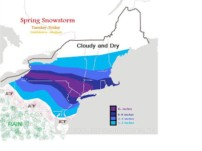
It looks like we will be having our first storm coming through the area tonight into the day on Thursday! Still, around 12 hours away, there is a load of uncertainties. For now I must give it my best shot though.
a onblur="try {parent.deselectBloggerImageGracefully();} catch(e) {}" href="http://3.bp.blogspot.com/-dNUjdja2pCo/TYj253aRogI/AAAAAAAAAYo/OAx6gWQxllM/s1600/Spring%2BSnow.jpg">

Now before anyone gets too excited or disappointed,I must say that this map was made yesterday, and is going to need quite a few tweaks to it, but it has the general idea. For example, I no longer think NYC will be receiving 4-6 inches of snow; 2-4 seems to be most reasonable at this point.
Details on the next storm should be introduced here on Thursday and Friday, and those days will also include details on the storm after that! The way it looks now is we will eventually see a major snowstorm take shape along the eastern seaboard.
-Scott Pecoriello


