Hey everybody... The high in fort Myers today was only 59 degrees today... Opposed to an average of around 75 degrees... I know what those of you who live in the northeast and mid-Atlantic states are thinking... I should be very happy because some of you may barely reach freezing today... For the most part I'm happy, but the wind makes it feel closer to around 49 for a high today, even though those of you in the northeast and mid- Atlantic would even take 49 for a high but I can say with confidence that 49 degrees won't happen for a very long time... In fact it will probably only get colder for you. As for you in Florida we should have a slow warm up where temperatures may get close to 70 degrees until about Tuesday where a weak cold front will come through and move temperatures back into the lower 60s and unfortunately some of you may get back into the upper 50s... The good news is the sun will be out for at least the next week with maybe some rain on Tuesday as the front comes through, and the wind will really calm down so at dome points it may feel 5 or 10 degrees warmer then the actual temperature...after the cold front on Tuesday it looks like another cold front will take place late Saturday and into Sunday but before that some of you may hit 80 in southern Florida ahead of the cool front... Everyday this week until Saturday I will have this kind of intro with the weather in Florida!!!! Now to the snowy news...
A clipper system will drop through the Midwest giving most people 1-3 inches with locally 4 or 5 inches and then as you make your way toward Ohio and into west Virginia you will see somewhere around 3-6 inches with locally 8 or 9 inches... Now once you get into southeastern PA and into DC, Baltimore and up toward NYC and Boston you will see anywhere from 6-9 with locally a foot as this storm looks to strengthen once reaching the Atlantic ocean... Remember SE PA includes Philly... So it seems the I-95 corridor will once again get hit by a snowstorm... Keep in mind that this is not a blizzard with 1-2 locally 3 feet... We will see though some heavy snow with a little wind, especially as the storm begins to strengthen over sea...
Now this clipper is the 6th major snowstorm to hit the eastern 3rd of the country.. And it seems we have spotted a 7th and believe it or not this may be the most powerful of all the storms which is absolutely insane considering the last 2 storms have dropped anywhere from 2-3 1/2 feet of snow with winds close to hurricane force... So u can only imagine what this storm may hold ... Thats it for now... I'll update around 10 tonight!
Saturday, February 13, 2010
Potential blizzard again
http://www.accuweather.com/radar-regional.asp?level=regional&type=sir&site=NE
yes it looks like another potential blizzard for the Northeast and mid-Atlantic states...
yes it looks like another potential blizzard for the Northeast and mid-Atlantic states...


Friday, February 12, 2010
Goodbye Snow... Hello Sun... and for some Hello to the snow... AGAIN!!!! The south is in for it too!!!!
By the title you may think the snow is finally going to go away in the North East and Mid-atlantic...... But, NO... The reason that is my title is because I am in FLORIDA!!!... Nice, sunny and warm Florida... but no, Florida today is rainy and cold and far from nice... A cold front is currently coming through and it looks like parts of Northern Florida will be in the upper 30's and lower 40's!!!! In fact snow has actually been reported in parts of the Florida Panhandle!!!! In the mid-sections of Florida it looks like we will have temperatures in the mid to lower 50's and in the extreme souther parts of Florida you may barely reach 60! Really just yucky around here... but better then a foot of snow and winds making it feel like the -0's!
Yes that will be the case... The Northeast and Mid-Atlantic will see freezing temps and MORE SNOW!!!! and possibly a lot of it! Get this... Parts of the Mid-Atlantic may see 100 inches of snow before the end of feburary... and by march, who knows, we may be aprouching well over 100 inches!!!! Plus the average for most of these places are around 18 inches!!!! That would be more then 80 inches above Normal Snowfall!!!!
We are talking about the potential for the 5th or 6th major SNOWSTORM in the Mid-atlantic/Northeast!!!! I was just looking at previous blogs and saw 4 or 5 other snowstorms that slammed the East!!! This one looks to take the same exact path!!! The potential for 6-12+ inches is again there for you people from Roanoke to Boston... So i do not want to talk to much on this subject because its a little to far right now... even though this storm should hit monday and tuesday... but still. Today i would like our main focus to be on the SOUTHERN SNOWSTORM!!!!
This Winter is just insane and will be remember likely forever!!!! Dallas, TX: Almost a foot of snow!!!! You rarely ever see a foot of snow in Dallas... Snowfall accumulations reported all the way to mobile, MS which hasn't happened since the mid 1900's!!!! I said earlier that snowfall was even reported in the Florida Panhandle!!! Birmingham, Montgomery, and Atlanta saw anywhere from 3-6 even 7 or 8 inches!!! Heavy snow hit all of those areas and now is moving into SC and NC which could all see another 3-6 inches of heavy wet snowfall! That's it for now... I may update again later tonight on the Eastern Snowstorm!!!.....


Yes that will be the case... The Northeast and Mid-Atlantic will see freezing temps and MORE SNOW!!!! and possibly a lot of it! Get this... Parts of the Mid-Atlantic may see 100 inches of snow before the end of feburary... and by march, who knows, we may be aprouching well over 100 inches!!!! Plus the average for most of these places are around 18 inches!!!! That would be more then 80 inches above Normal Snowfall!!!!
We are talking about the potential for the 5th or 6th major SNOWSTORM in the Mid-atlantic/Northeast!!!! I was just looking at previous blogs and saw 4 or 5 other snowstorms that slammed the East!!! This one looks to take the same exact path!!! The potential for 6-12+ inches is again there for you people from Roanoke to Boston... So i do not want to talk to much on this subject because its a little to far right now... even though this storm should hit monday and tuesday... but still. Today i would like our main focus to be on the SOUTHERN SNOWSTORM!!!!
This Winter is just insane and will be remember likely forever!!!! Dallas, TX: Almost a foot of snow!!!! You rarely ever see a foot of snow in Dallas... Snowfall accumulations reported all the way to mobile, MS which hasn't happened since the mid 1900's!!!! I said earlier that snowfall was even reported in the Florida Panhandle!!! Birmingham, Montgomery, and Atlanta saw anywhere from 3-6 even 7 or 8 inches!!! Heavy snow hit all of those areas and now is moving into SC and NC which could all see another 3-6 inches of heavy wet snowfall! That's it for now... I may update again later tonight on the Eastern Snowstorm!!!.....


Wednesday, February 10, 2010
9:30 PM EST Update... snow still coming down..... And HARD.....
It is 9:30 PM and just a quick update here on the snow... It seems more of an unexpected kind of thing going on right now... Heavy snow and wind and still blizzard like conditons are still going on as of 9:30 and BLIZZARD CONDITIONS will last it looks like till 11:00 PM EST along southern New England and NYC... This does NOT include philly, DC, and Baltimore... But it does include Westport, Hartford, Providence and Boston which i believe will see another 3-6 inches!!! Blizzard conditons should end around 11:00 but still light to moderate snow is possible till 1:00 or 2:00 AM... All snow should end by 5:00 AM in southern New england... Though Blowing and drifting snow will last into late thursday which may lead to school delays and cancellations across the area, plus as temperatures drop the snow on roads will begin to freeze in place and areas will look like Antartica! Some totals as of right now are...:
Westport: 12 inches (still snowing)
NYC: 9 inches (still snowing)
Great kills: 15 inches (still snowing)
Philly: 14 inches (flurrying)
DC: 10.5 inches (Snow is for the most part done)
Baltimore: 19 inches!(Snow for the most part is done)
Fanwood, NJ: 16.5 inches
Yonkers: 12.2
Orient : 11.5
Greenwich: 10
Parkchester: 9.4
Perkasie: 19.8!
Ewing: 17.5
Hillsborough: 15
East brunswick: 13
Edison: 10.5
Budd Lake: 10
Some crazy and exciting news is that WASHINGTON, D.C., BALTIMORE, MD and PHILADELPHIA, PA have officially broke the record of the MOST SNOW IN A WINTER with over 70 inches of snow in these areas! and winter is NOT close to over! In fact it looks like another storm may drop several inches of snow monday and tuesday but across the Northeast it may be another monster storm... too early to say exactly what happens. That's it for right now... check back soon!
Current radar still shows monster blizzard...
Westport: 12 inches (still snowing)
NYC: 9 inches (still snowing)
Great kills: 15 inches (still snowing)
Philly: 14 inches (flurrying)
DC: 10.5 inches (Snow is for the most part done)
Baltimore: 19 inches!(Snow for the most part is done)
Fanwood, NJ: 16.5 inches
Yonkers: 12.2
Orient : 11.5
Greenwich: 10
Parkchester: 9.4
Perkasie: 19.8!
Ewing: 17.5
Hillsborough: 15
East brunswick: 13
Edison: 10.5
Budd Lake: 10
Some crazy and exciting news is that WASHINGTON, D.C., BALTIMORE, MD and PHILADELPHIA, PA have officially broke the record of the MOST SNOW IN A WINTER with over 70 inches of snow in these areas! and winter is NOT close to over! In fact it looks like another storm may drop several inches of snow monday and tuesday but across the Northeast it may be another monster storm... too early to say exactly what happens. That's it for right now... check back soon!
Current radar still shows monster blizzard...

THE BLIZZARD HAS BEGUN.....
YES, the blizzard has begun right outside my house and across much of the tri-state, mid-atlantic, and even northeast area! But has the blizzard really begun... The answer to that is no!!!! The two low pressures are still seperate and until they come together the true blizzard will not start... you can see those two seperate low trying to come together in the picture below...
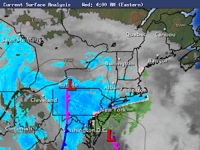
Once those two do come together it will bomb off the coast... Blizzard Warnings are currently in affect for NYC, Philly, and DC... i do believe they will extend through the southern New england area, or at least should, and even just south and west of Boston...
Outside currently in Southwestern CT there is some snow definitley picking up in intensity right now and moderate to even heavy... and the real storm hasn't even taken over yet so again 12-24 is still in the forecast for someone around this southern New england NYC, Philly, and NJ area...
That's it for now... very busy today with this monster storm!... ill have another post when things really begin to get crazy... right now there's are 3 inches of snow... another 8-12 is likely!!! Here's a map of the rest that hasn't been explained!...
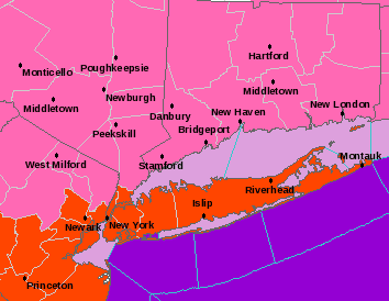
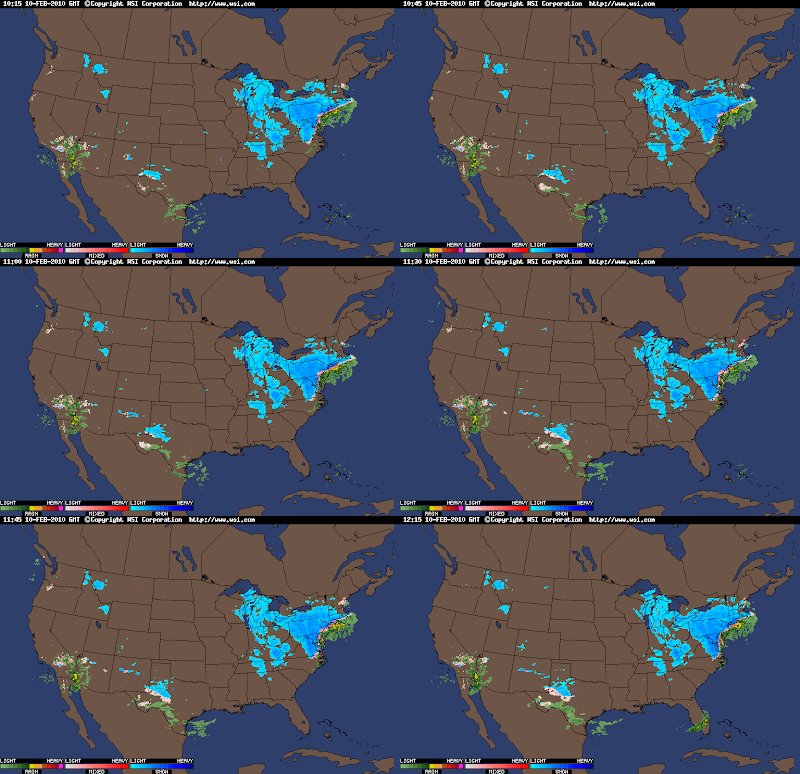
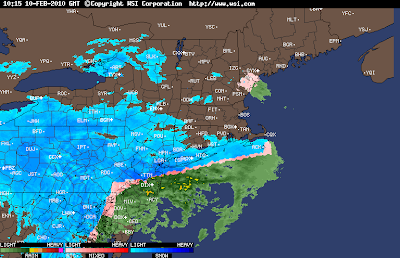

Once those two do come together it will bomb off the coast... Blizzard Warnings are currently in affect for NYC, Philly, and DC... i do believe they will extend through the southern New england area, or at least should, and even just south and west of Boston...
Outside currently in Southwestern CT there is some snow definitley picking up in intensity right now and moderate to even heavy... and the real storm hasn't even taken over yet so again 12-24 is still in the forecast for someone around this southern New england NYC, Philly, and NJ area...
That's it for now... very busy today with this monster storm!... ill have another post when things really begin to get crazy... right now there's are 3 inches of snow... another 8-12 is likely!!! Here's a map of the rest that hasn't been explained!...


Tuesday, February 9, 2010
Hey everyone... again i can not express just how excited i am. And if i were to this blog would take an hour to read... so i am not... Lets get right to it.
The snow looks like it has already begun across DC, Baltimore, even Philly! Already a couple inches in those areas... I am a little disappointed again at The Weather Channel. They aren't expressing just how bad its going to be... AND I REPEAT... I AM NOT HYPING!!!! This is going to be another HISTORICAL storm... A monster blizzard... in fact Accuweather.com has clearly expressed that this storm in a lot of ways will be worse then the last one. First off, its a week day! School is already cancelled all over SW CT... NYC closed this afternoon!!!! not heard of!!!! DC is closing for the 3rd day in a row... Some kids haven't had school for 6 days now!!!! 6!!!! that's crazy, but keep in mind this is including the weekend. But still! I would not be surprised if schools were closed again in SW CT Thursday and maybe even Friday and I'll tell you why, but first my other 2 reasons why this is worst. It will be impacting The entire Midwest and a good portion of the southern of the Northeast and once again the mid- Atlantic... so much more space is being covered by this storm. Plus this could be a foot or two on top of the already two or three feet already on the ground. And finally reason 3 is... just the blizzard is going to be 2 times worse then the storm before even if we don't get 3 1/5 feet of snow... someone could easily see 2 feet of snow plus severe blowing and drifting snow for 2-3 maybe more DAYS!!!! With the last storm it was much it was a wetter, heavier snow which couldn't blow until the end of the storm of the storm, and it was only 2 or 3 inches blowing... this is 1-2 feet blowing (it will be a very hard storm to measure). It will be a true blizzard!!!
So now the reason why i think that some schools could be closed through Friday is because of the mad blowing and drifting snow which will be around for 2-3 days! So just wanted mention that, so kids, get excited if you live in southern New England, Southeastern NY, and Northeastern NJ... This is all including long island and also i almost forgot eastern PA... Now let's talk about, annoying, Philadelphia...
OK, here's the deal, i am truly jealous of Philly... First Storm: 28 inches! Second storm: another 10-20 inches is possible so a total of 48 inches(4 feet of snow) is possible by thursday! so we shall see. I'm going to focus on 2 more cities today... One being Philly which i just did, the 2nd being NYC, and the final one being boston!
NYC my forecast is for around 10-20 inches... I am really pushing this possible 20 inches of snow... and possibly 24 inches!!! I think a full out blizzard is in store for NYC... Now the important thing to note is snow may begin to fall in the next hour but will not be steady until probably 8,9, maybe even 10 O'clock A.M. where the snow will become very heavy along with winds gusting past 40 mph, and maybe even close to, or past, 50 mph!!!! so 1-2 feet of snow... 50 mph winds.... and drifts possibly close to 4 or 5 + feet!!!! BLIZZARD OF 2010!!!!
Now to Boston, which i feel bad hasn't really been discussed much throughout this storm, and even throughout the winter... which is wrong... and that is because a foot of snow is possible in Boston by friday... Winds up to 50 mph are possible... and blowing and drifting snow... so why isn't boston being mentioned? well i think it is because 6-10 (locally 12) is possible... and that's not the highest snowfall possible... so i think that since Boston isn't going to get 24 inches of snow, The Weather Channel has decided not to pay attention to them... wrong decision, because come time for the storm to blow up along the coast, it's going to be a full blown blizzard!!!! so Watch out
Now to conclude... We are having a monster blizzard, and probably one that will be put in the record books... now to talk bulls eye, or the target!!! I believe this area will be from Northeastern Philly, through central and Northern NJ, and and then clip eastern PA, and finally i think the NYC, Long Island, Southern New England area will be slammed... and before i'm done, this is very important, SLEET and even rain may become a problem and reduce some total for Philly, Baltimore, and DC!!! so look for that... Below is a map that i created and i believe these are our snow totals... for those of you that can not read the map, don't worry, i made some typed up totals... By the way, Flights are already being cancelled for thursday around the Tri-State area, so check for flight issues!!!! that's it for now... Plenty more updates in the Next 24-48 hours! have a great SNOW DAY!!!! Enjoy the map, and potential totals!!!!
This is in affect through friday afternoon...

Snow Totals(keep in mind these are predictions, look at the ranges more!):
NYC : 12-18(24) inches... 20 inches
Philly : 12-18(24) inches... 18 inches
Hartford : 12-18(24) inches... 16 inches
Berkshires: 6-10(12) inches... 7.5 inches
Concord : 2-4(6) inches... 5 inches
Boston : 6-10(12) inches... 10 inches
Trenton : 12-18(24) inches... 18 inches
Baltimore : Northern Side: 6-10(12) Southern Side: 2-4(6)
DC : Northern Side: 6-10(12) Southern Side: 2-4(6)
Monsey : 12-18 inches... 14 inches
Scranton : 6-10(12) inches... 8 inches
Chatham : 2-4(6) inches... 5 inches (lots of mix possible)
Long island area: Western area: 12-18(24)...15 inches Mid area: 6-10(12)...7 inches Eastern Area: 2-4(6) 5.5 inches
Have a good rest of the day!
The snow looks like it has already begun across DC, Baltimore, even Philly! Already a couple inches in those areas... I am a little disappointed again at The Weather Channel. They aren't expressing just how bad its going to be... AND I REPEAT... I AM NOT HYPING!!!! This is going to be another HISTORICAL storm... A monster blizzard... in fact Accuweather.com has clearly expressed that this storm in a lot of ways will be worse then the last one. First off, its a week day! School is already cancelled all over SW CT... NYC closed this afternoon!!!! not heard of!!!! DC is closing for the 3rd day in a row... Some kids haven't had school for 6 days now!!!! 6!!!! that's crazy, but keep in mind this is including the weekend. But still! I would not be surprised if schools were closed again in SW CT Thursday and maybe even Friday and I'll tell you why, but first my other 2 reasons why this is worst. It will be impacting The entire Midwest and a good portion of the southern of the Northeast and once again the mid- Atlantic... so much more space is being covered by this storm. Plus this could be a foot or two on top of the already two or three feet already on the ground. And finally reason 3 is... just the blizzard is going to be 2 times worse then the storm before even if we don't get 3 1/5 feet of snow... someone could easily see 2 feet of snow plus severe blowing and drifting snow for 2-3 maybe more DAYS!!!! With the last storm it was much it was a wetter, heavier snow which couldn't blow until the end of the storm of the storm, and it was only 2 or 3 inches blowing... this is 1-2 feet blowing (it will be a very hard storm to measure). It will be a true blizzard!!!
So now the reason why i think that some schools could be closed through Friday is because of the mad blowing and drifting snow which will be around for 2-3 days! So just wanted mention that, so kids, get excited if you live in southern New England, Southeastern NY, and Northeastern NJ... This is all including long island and also i almost forgot eastern PA... Now let's talk about, annoying, Philadelphia...
OK, here's the deal, i am truly jealous of Philly... First Storm: 28 inches! Second storm: another 10-20 inches is possible so a total of 48 inches(4 feet of snow) is possible by thursday! so we shall see. I'm going to focus on 2 more cities today... One being Philly which i just did, the 2nd being NYC, and the final one being boston!
NYC my forecast is for around 10-20 inches... I am really pushing this possible 20 inches of snow... and possibly 24 inches!!! I think a full out blizzard is in store for NYC... Now the important thing to note is snow may begin to fall in the next hour but will not be steady until probably 8,9, maybe even 10 O'clock A.M. where the snow will become very heavy along with winds gusting past 40 mph, and maybe even close to, or past, 50 mph!!!! so 1-2 feet of snow... 50 mph winds.... and drifts possibly close to 4 or 5 + feet!!!! BLIZZARD OF 2010!!!!
Now to Boston, which i feel bad hasn't really been discussed much throughout this storm, and even throughout the winter... which is wrong... and that is because a foot of snow is possible in Boston by friday... Winds up to 50 mph are possible... and blowing and drifting snow... so why isn't boston being mentioned? well i think it is because 6-10 (locally 12) is possible... and that's not the highest snowfall possible... so i think that since Boston isn't going to get 24 inches of snow, The Weather Channel has decided not to pay attention to them... wrong decision, because come time for the storm to blow up along the coast, it's going to be a full blown blizzard!!!! so Watch out
Now to conclude... We are having a monster blizzard, and probably one that will be put in the record books... now to talk bulls eye, or the target!!! I believe this area will be from Northeastern Philly, through central and Northern NJ, and and then clip eastern PA, and finally i think the NYC, Long Island, Southern New England area will be slammed... and before i'm done, this is very important, SLEET and even rain may become a problem and reduce some total for Philly, Baltimore, and DC!!! so look for that... Below is a map that i created and i believe these are our snow totals... for those of you that can not read the map, don't worry, i made some typed up totals... By the way, Flights are already being cancelled for thursday around the Tri-State area, so check for flight issues!!!! that's it for now... Plenty more updates in the Next 24-48 hours! have a great SNOW DAY!!!! Enjoy the map, and potential totals!!!!
This is in affect through friday afternoon...

Snow Totals(keep in mind these are predictions, look at the ranges more!):
NYC : 12-18(24) inches... 20 inches
Philly : 12-18(24) inches... 18 inches
Hartford : 12-18(24) inches... 16 inches
Berkshires: 6-10(12) inches... 7.5 inches
Concord : 2-4(6) inches... 5 inches
Boston : 6-10(12) inches... 10 inches
Trenton : 12-18(24) inches... 18 inches
Baltimore : Northern Side: 6-10(12) Southern Side: 2-4(6)
DC : Northern Side: 6-10(12) Southern Side: 2-4(6)
Monsey : 12-18 inches... 14 inches
Scranton : 6-10(12) inches... 8 inches
Chatham : 2-4(6) inches... 5 inches (lots of mix possible)
Long island area: Western area: 12-18(24)...15 inches Mid area: 6-10(12)...7 inches Eastern Area: 2-4(6) 5.5 inches
Have a good rest of the day!
Monday, February 8, 2010
Blizzard of 0'10 # 2.... Bigger, Better, and Stronger?
HEY EVERYBODY!!!! I am beyond excited today and im sure you can guess why from the title. Yes, Blizzard of 0'10 #2.... Bigger, Better, and Stronger? This looks to be another monster snowstorm... We could be talking again another 1-2 feet + of snow in some spots. Tonight im going to talk about where the heaviest snow is going to be, including some predictions of totals, and also just how heavy it will be. I'm also going to talk about what this snow is going to cause and the impact!!!!....
So here are my current predictions for the snowstorm!!!! keep in mind these may change come tomorrow...
Chicago : 14 inches
Detriot : 9.5 inches
Indianapolis: 8.5 inches
Columbus : 11 inches
Cleveland : 8 inches
Grand Rapids: 12 inches
Buffalo : 2 inches
Pittsburgh : 8 inches
Lexington : 5 inches
Louiville : 5 inches
Buckhannon : 10 inches
Richmond : 1.5 inches
Roanoke : 5 inches
DC : 14 inches ( on top of 3 feet already on the ground!)
Baltimore : 15 inches
Philadelphia: 22 inches
Scranton : 8 inches
Binghamton : 7 inches
NYC : 24 inches
Otis : 7 inches
Concord : 4 inches
Hartford : 14 inches
Boston : 12 inches
Chatham : 6 inches
Portland : 2 inches
Westport : 24 inches
The highest snow amount i could put is 24 but it could exceed that. So watch out in Philly, NYC, Westport, and Hartford where you will see likely 2 feet and winds in excess of 35 mph... A MAJOR BLIZZARD!!!! Drifting and blowing snow will likely impact the area so Thursday and maybe even Friday will be hard on travel... Temps. during this storm will quickly drop to the lower teens with wind chills below zero... since i have to go, i will put up a couple maps from accuweather that should explain the rest... Much more on the storm tomorrow!!!!


So here are my current predictions for the snowstorm!!!! keep in mind these may change come tomorrow...
Chicago : 14 inches
Detriot : 9.5 inches
Indianapolis: 8.5 inches
Columbus : 11 inches
Cleveland : 8 inches
Grand Rapids: 12 inches
Buffalo : 2 inches
Pittsburgh : 8 inches
Lexington : 5 inches
Louiville : 5 inches
Buckhannon : 10 inches
Richmond : 1.5 inches
Roanoke : 5 inches
DC : 14 inches ( on top of 3 feet already on the ground!)
Baltimore : 15 inches
Philadelphia: 22 inches
Scranton : 8 inches
Binghamton : 7 inches
NYC : 24 inches
Otis : 7 inches
Concord : 4 inches
Hartford : 14 inches
Boston : 12 inches
Chatham : 6 inches
Portland : 2 inches
Westport : 24 inches
The highest snow amount i could put is 24 but it could exceed that. So watch out in Philly, NYC, Westport, and Hartford where you will see likely 2 feet and winds in excess of 35 mph... A MAJOR BLIZZARD!!!! Drifting and blowing snow will likely impact the area so Thursday and maybe even Friday will be hard on travel... Temps. during this storm will quickly drop to the lower teens with wind chills below zero... since i have to go, i will put up a couple maps from accuweather that should explain the rest... Much more on the storm tomorrow!!!!


Subscribe to:
Posts (Atom)