Weather Forecast:
Part 1: First severe weather of the year
Part 2: More on active volcano(s)
Part 3: RAIN...
Part 4: Westport Weather Update...
Part 1:
Those of you from Pittsburgh to State College, all the way to Philly and Dover, and back toward DC and Baltimore, you've been pretty lucky today with no real heavy rain... Well it looks like your luck just ran out... According to numerous models, and the National Weather service, severe weather is on the way!!!! So whats going on? When is it coming? Heavy thunderstorms have already affected North Western Indiana, Southern Michigan, and parts of Northern Ohio... These thunderstorms contain large hail, heavy rain, local wind damage, and isolated tornado's!!!! Right now these thunderstorms are spinning around a large counter-clockwise low pressure system right on the border line of Illinois and Indiana... As the thunderstorms spin around in that counter-clockwise spin, they should begin to extend right into our region... So this is a warning for areas from PA to southern NJ and right back down to Virginia and south and west... North of Philly though, it should be just a heavy rain, due to much more stable air and cooler temperatures... So it looks like NYC, Boston, Albany, and north will get lucky on this one... So just a recap, look for thunderstorms beginning to pop up by about 3 or 4 PM... It is likely that the thunderstorms will be severe and may produce large hail, strong and possibly damaging winds, heavy rain, and even isolated tornadoes... So watch out if you're included in any of these areas, or the surrounding ones...
Part 2:
Not too much new information on the active volcano's except for some new lava flow off eyjafjallajokull, which scientists believe is nothing out of the normal, and shouldn't mean anything... As of 2 hours ago, scientist are still confident that Katla will erupt... Now to some of the good news... European aviation's are finally doing something, and coming up with a plan to re-route the planes in the case that the volcano does erupt... But Europe, being a popular tourist destination, has flights coming in and out of almost every country in the world... So the next step needs to be other countries taking action in re-routing there flights and coming up with an aviation plan... Considering Katla is nearly 100x stronger than eyjafjallajokull, the ash cloud which would affect aviation may spread around further than just Europe which really makes it an important move to come up with an aviation plan... That's it from here for now, I'll keep you updated with more on the volcano...
Part 3:
RAIN... Well its pretty obvious that very few people like the rain, but we should get used to it, because it seems like it will be around for at least the early half of the week... So lets get to the details... The whole storm has come earlier then expected... Much earlier... The first batch of rain came last night and very early this morning for most people south of Boston and Albany... So now instead of the second batch being tomorrow, it will be tonight with the break in the rain today... Also tomorrow it seems a third batch might come through later in the afternoon lasting into early Tuesday... So look for a general total in the rain in the 2-4 inches of rain, with locally higher amounts the further south you go, when you run into some of the thunderstorms... So get used to the rain, because it may be here for a while...
Part 4:
As mentioned in part 3, everything has been shifted up, which works out nicely because it means not a lot of rain for the afternoon... The first batch of rain moved in last night, and ended early this morning, the next step is this 5-8 hour pause in the rain which is currently taking place and should last until around 8 PM with some spotty showers earlier on... After 8 PM, look for a moderate to heavy rain lasting until early tomorrow morning... This is batch 2 of the rain... Then we may have a 3-5 hour pause before batch 3 moves in around 10 or 11 AM tomorrow morning, which will last until Tuesday morning before finally clearing out!!!! Wednesday afternoon look for climbing temperatures and clearing skies...
-Scott Pecoriello
Sunday, April 25, 2010
Saturday, April 24, 2010
Why people are still concerned about Iceland???? And the rain will be felt across the Northeast...
Weather Forecast:
Part 1: Iceland volcano's still a problem... Why?
Part 2: Heavy rain on the way...
Part 3: Westport Weather Update...!
Part 1:
I told you the next update would be mostly about the volcano problems, so here it is!!!! Right now i am going to make a comparison... Now i don't know how good it is, but it will have to do... Do you remember the Chile earthquake, back a couple months ago, and how it posted the threat for a tsunami all across Hawaii???? And then, nothing ever really happened???? Well this is similar, except of course, the fact that this is a volcano!!!! We know that Eyjafjallajokull has already erupted in Iceland, and as you know, caused one of the worst, if not the worst airline disruption ever... we also know that Eyjafjallajokull has quited down quite a bit... Even though there is still a lava flow down the mountain, the active explosions have stopped... This is good because now all airlines are pretty much back to there normal schedule... This is where the bad news comes in though, because if we go way back to 920, 1612, and then 1821-1823 Eyjafjallajokull has erupted...
Eyjafjallajokull:
So what's the big deal about this? Well Eyjafjallajokull's neighbor, Katla, has erupted right after Eyjafjallajokull each time, in 920, 1612, and even 1821-1823... Something that you should also know is that Katla is about 100 times stronger then Eyjafjallajokull!!!! So the eruption would be far worse, probably beyond most people's imagination... You can only imagine the problems it would cause for the airlines in Europe... This ash cloud would be MASSIVE (close to 100x larger then the one from Eyjafjallajokull) and could easily spread past Europe, and possibly around the whole world... Iceland has been worried about the eruption from Katla since 1999...
Katla:

The story even gets worse!!!! 4 days ago on April 20th 2010, Iceland President Olafur Grimsson said "the time for Katla to erupt is coming close... we [Iceland] have prepared... It is high time for European governments and airline authorities all over the world to start planning for the eventual Katla eruption"... Well that certainly scared me, and i don't think the US government or airline authorities have talked enough about this, especially to the public... Lets just keep our fingers crossed, and hope it doesn't erupt...
Part 2:
NYC and north, you're pretty lucky for today because you really are going to have sunny blue skies for most of the day, while Philly and Southern sections of PA (with the exception of SW PA) will be pretty cloudy and cool the whole day, and south of there it looks to be rainy... Enjoy whatever time you can of sunshine and warmth because it will be fading rather quickly... If you haven't already gotten rain then you will be time midnight and tomorrow morning come around... I'm not going to go over the time line for each area for you, because for that you can just go to your local weather, but instead I'm going to go over just how bad this storm will be... Let's start with the heaviness... What seems to be going on is, the major cities will see a heavy batch of rain sometime tomorrow depending on which city your in... most are going to see 1-2 inches of rain just from the first hit tomorrow... Tomorrow night it actually might clear out and it will be a good 10-15 degrees cooler... This small pause in the action will lead to the second batch, which should arrive sometime on Monday, again depending on which city you are in... This batch will drop again another 1-2 inches of heavy rain, and should begin to lighten up by Tuesday morning... But this doesn't mean stop... Looks like a nasty mist and light rain, occasionally moderate, may last until Wednesday evening before becoming hit and miss showers... It will be very cool over the next couple of days, but a gradual warm up is likely starting Thursday...
Part 3:
Hope everyone is enjoying this sunny and warm Saturday because it will not last for long... In fact, you can expect showers to start moving into the area by close to midnight tonight... Right now we're currently watching a band of light rain moving through sections of PA, as it slowly looses its steam, so it is possible we see a shower or two around 5 or 6 o'clock, but nothing to really ruin the day... You will notice the clouds on the increase though, and temperatures will slowly be dropping as we make our way toward night fall... So again, expect rain by about midnight, with the heavy stuff starting toward the morning and lasting right into the afternoon... This is only the first batch though... From this batch alone we could see 1-2 inches of rain easily... Tomorrow night it should actually clear out, with just some cloudy skies and a couple of pop up showers... But by Monday, batch two will come around with more heavy rain and an additional 1-2 inches... This batch will last into the very early hours of Tuesday before tapering to a couple of showers Tuesday morning... It doesn't stop there though, expect mist and light showers throughout all of Tuesday and even into parts of Wednesday, as the showers become more scattered... It will be very cool over the next couple of days, maybe 5-10 degrees colder then today, but after Wednesday, a gradual warm up will take place, and we could hit 70 by Friday with sunshine...
Westport, CT:

-Scott Pecoriello
Part 1: Iceland volcano's still a problem... Why?
Part 2: Heavy rain on the way...
Part 3: Westport Weather Update...!
Part 1:
I told you the next update would be mostly about the volcano problems, so here it is!!!! Right now i am going to make a comparison... Now i don't know how good it is, but it will have to do... Do you remember the Chile earthquake, back a couple months ago, and how it posted the threat for a tsunami all across Hawaii???? And then, nothing ever really happened???? Well this is similar, except of course, the fact that this is a volcano!!!! We know that Eyjafjallajokull has already erupted in Iceland, and as you know, caused one of the worst, if not the worst airline disruption ever... we also know that Eyjafjallajokull has quited down quite a bit... Even though there is still a lava flow down the mountain, the active explosions have stopped... This is good because now all airlines are pretty much back to there normal schedule... This is where the bad news comes in though, because if we go way back to 920, 1612, and then 1821-1823 Eyjafjallajokull has erupted...
Eyjafjallajokull:

So what's the big deal about this? Well Eyjafjallajokull's neighbor, Katla, has erupted right after Eyjafjallajokull each time, in 920, 1612, and even 1821-1823... Something that you should also know is that Katla is about 100 times stronger then Eyjafjallajokull!!!! So the eruption would be far worse, probably beyond most people's imagination... You can only imagine the problems it would cause for the airlines in Europe... This ash cloud would be MASSIVE (close to 100x larger then the one from Eyjafjallajokull) and could easily spread past Europe, and possibly around the whole world... Iceland has been worried about the eruption from Katla since 1999...
Katla:

The story even gets worse!!!! 4 days ago on April 20th 2010, Iceland President Olafur Grimsson said "the time for Katla to erupt is coming close... we [Iceland] have prepared... It is high time for European governments and airline authorities all over the world to start planning for the eventual Katla eruption"... Well that certainly scared me, and i don't think the US government or airline authorities have talked enough about this, especially to the public... Lets just keep our fingers crossed, and hope it doesn't erupt...
Part 2:
NYC and north, you're pretty lucky for today because you really are going to have sunny blue skies for most of the day, while Philly and Southern sections of PA (with the exception of SW PA) will be pretty cloudy and cool the whole day, and south of there it looks to be rainy... Enjoy whatever time you can of sunshine and warmth because it will be fading rather quickly... If you haven't already gotten rain then you will be time midnight and tomorrow morning come around... I'm not going to go over the time line for each area for you, because for that you can just go to your local weather, but instead I'm going to go over just how bad this storm will be... Let's start with the heaviness... What seems to be going on is, the major cities will see a heavy batch of rain sometime tomorrow depending on which city your in... most are going to see 1-2 inches of rain just from the first hit tomorrow... Tomorrow night it actually might clear out and it will be a good 10-15 degrees cooler... This small pause in the action will lead to the second batch, which should arrive sometime on Monday, again depending on which city you are in... This batch will drop again another 1-2 inches of heavy rain, and should begin to lighten up by Tuesday morning... But this doesn't mean stop... Looks like a nasty mist and light rain, occasionally moderate, may last until Wednesday evening before becoming hit and miss showers... It will be very cool over the next couple of days, but a gradual warm up is likely starting Thursday...
Part 3:
Hope everyone is enjoying this sunny and warm Saturday because it will not last for long... In fact, you can expect showers to start moving into the area by close to midnight tonight... Right now we're currently watching a band of light rain moving through sections of PA, as it slowly looses its steam, so it is possible we see a shower or two around 5 or 6 o'clock, but nothing to really ruin the day... You will notice the clouds on the increase though, and temperatures will slowly be dropping as we make our way toward night fall... So again, expect rain by about midnight, with the heavy stuff starting toward the morning and lasting right into the afternoon... This is only the first batch though... From this batch alone we could see 1-2 inches of rain easily... Tomorrow night it should actually clear out, with just some cloudy skies and a couple of pop up showers... But by Monday, batch two will come around with more heavy rain and an additional 1-2 inches... This batch will last into the very early hours of Tuesday before tapering to a couple of showers Tuesday morning... It doesn't stop there though, expect mist and light showers throughout all of Tuesday and even into parts of Wednesday, as the showers become more scattered... It will be very cool over the next couple of days, maybe 5-10 degrees colder then today, but after Wednesday, a gradual warm up will take place, and we could hit 70 by Friday with sunshine...
Westport, CT:
-Scott Pecoriello
Wednesday, April 21, 2010
Quick update due to flying...
Weather Forecast:
Part 1: Quick Update...
Part 1:
Just a quick update because i will be flying today...
1. Scattered showers today, generally south of NYC, but a couple of sprinkles will be north of there... The scattered showers may be moderate at times with even a couple of thunderstorms...
2. Seems airports in Europe are beginning to make a slow recovery after nearly a week of airports being shut down... The total cost as of now is 1.7 billion dollars... Tomorrow i will tell you why airports may shut down again...
3. The mid and lower 60's across the northeast will probably begin to lower back into the mid and upper 50's by Sunday, but the models continue to show warming as we get closer to May...
That's it for now... Again, sorry for the short update... It should be back to normal this week...
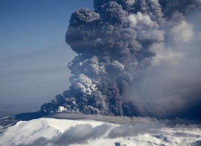
Here are some amazing photos of the Volcano from this week...


-Scott Pecoriello
Part 1: Quick Update...
Part 1:
Just a quick update because i will be flying today...
1. Scattered showers today, generally south of NYC, but a couple of sprinkles will be north of there... The scattered showers may be moderate at times with even a couple of thunderstorms...
2. Seems airports in Europe are beginning to make a slow recovery after nearly a week of airports being shut down... The total cost as of now is 1.7 billion dollars... Tomorrow i will tell you why airports may shut down again...
3. The mid and lower 60's across the northeast will probably begin to lower back into the mid and upper 50's by Sunday, but the models continue to show warming as we get closer to May...
That's it for now... Again, sorry for the short update... It should be back to normal this week...
Here are some amazing photos of the Volcano from this week...


-Scott Pecoriello
Monday, April 19, 2010
A LOT TO TALK ABOUT...
Weather Forecast:
Part 1: Its been a while... why?
Part 2: Blog shifts from weather... to natural disaster...(Must See)
Part 3: Weather... Normal...
Part 4: Westport Weather...
Part 1:
Well, remember the day i was supposed to show the first video blog? Wow was that a bad day... So what exactly happened? Well, you know the short videos that i show, sometimes of storm damage? Those videos are only between 10 seconds and 45 seconds long... These short videos take about 5 minutes to upload onto the blog... So when i recorded a 10 minute long video... Well i think you can understand... The computer almost had a heart attack... So is that it for the video blog? Well what i hope to do is this... I am hoping i can split the videos into parts, just like i normally do on the blog, that way each part is only 1-2 minutes... So, this isn't it for the video blog, and I'll keep you updated on what we decide! Thanks for understanding, and I'm sorry i haven't blogged in a while... The whole video thing kind of threw me off...
Part 2:
I am sure you have all heard by now, whether it's affecting you or not, about the volcano eruption in Iceland!!!! On top of that, the extent of what this eruption is doing... It's affecting health, travel, and economy... But there are a lot of details about this disaster that many don't know... First of all, how often does this volcano actually erupt? Well, not since the 1800's!!!! So not very often... In fact, until recently, it has been under the dormant category... Even though the airports hope to begin flights again sometime this week, how likely is that? Well, it's not very likely at all... There is only about a 30% chance that any of the major airports re-open sometime this week, and it is almost impossible to tell when the major airports will re-open... So why is it so hard to predict when the airports will re-open? This is because this volcano can stop erupting tomorrow... Or it can keep erupting for up to 1 year!!!! So what are the options for these airports? Well there are very few... One is to remain closed until they get the O.K. from the experts... Of course this would mean a major crash for the economy... The second option is to begin flying in the "no fly zone" This area is below the ash cloud, which is probably pretty low for a plane to fly... Even flying this low, the plane could still be affected by the ash clouds... The last option, which i am strongly against, is trying to just fly normally, and hope for the best... This one sounds stupid, but it is one that the airports are considering... They have been fly passenger less flights over the past couple of days, trying to avoid the ash clouds, and according to the associated press, all flights have been successful with no reported damage... Of course, it is not only the flights being affected by this disaster... It's the economy as well... Already, an estimated price of 800 million dollars has been lost, and each day, they are loosing up to 154 million dollars!!!! If travel and economy weren't already enough, health is doing poorly too... Experts are already issuing health warnings and advisories all across Europe, as the ash cloud falls down toward the ground... Keep here for more updates on the continuing disaster...
Part 3:
Well, the continuing weather story... Normal... Temperatures all across the Northeast are returning back to normal, after the freezing and even snowy weekend for some... The upcoming week will be completely average... With temperatures in the upper 50's, lower 60's, and even some mid and upper 60's, further south...
Part 4:
Just quickly... Westport will be nice and very sunny this week, so enjoy the break... Temps will be in the 60's with sunshine the whole week...
-Scott Pecoriello
Tuesday, April 13, 2010
VIDEO BLOG IS NOT READY...
Sorry for the delay... It will be posted sometime later tonight, so if you don't want to wait up until later, you can just check tomorrow
-scott Pecoriello
-scott Pecoriello
VIDEO BLOG ALMOST DONE...
Just in case anybody was wondering if the video blog was being posted today, it is... It is just taking time to download and should be completed by 9:00 PM, if not sooner... So be ready!!!! It turned out pretty good!!!!
-Scott Pecoriello
-Scott Pecoriello
Sunday, April 11, 2010
quick update again... NEWS ABOUT VIDEO BLOG...
Weather Forecast:
Part 1: Only real news in the northeast weather world...
Part 2: Big news on Video Blog...
Part 1:
Again, not much going on with the weather... Today though, the forecast was pretty far off for some of the major and local weather stations... For instance, NYC... The forecasted high for today was 69 degrees, meanwhile it hit 77 degrees today in NYC... So much warmer than predicted, plus the slight chance of a show never really happened... But what the chance of that shower represented, did happen... The shower represented a cold front coming through the whole northeast area... So those of you that experienced 70 degree weather today, are likely to be back into the lower 60's by tomorrow... This cool pattern will continue through this week and into next week...
Part 2:
The reason i haven't really been doing a lot of work on the blog over the past week, is because all the preparation for the video blog... Unfortunately, the preparation is taking longer then originally expected, so the video blog will be postponed until Tuesday, April 13Th, 2010... Currently we are waiting for a couple things to come together before this whole thing can work... So keep it here for more on this exciting event coming up, and be sure not to miss it!!!!
-Scott Pecoriello
Saturday, April 10, 2010
Quick Update...
Weather Forecast:
Part 1: Quick Update...
Part 1:
Sorry i haven't updated in a while, not much going on, so i'm just going to list some things to watch for...
1. Tuesday i am planning to dedicate the blog mostly to the upcoming hurricane season... Depending on how mondays video goes, will determine whether i do a video blog on tuesday, or a normal one...
2. Warm weather is gone, and very cool weather has taken its place... Cold weather extends all the way into next week...
3. generally dry northeast pattern shaping up, not too much in the way of rain...
So those are really the only 4 exciting things going on in the Northeast weather world right now, but stay tuned for more...
And remember!!!! Monday, April 12th, 2010... First video blog ever... Don't miss it...
-Scott Pecoriello
Tuesday, April 6, 2010
World Wide News is scarying me... Warmest day of April coming up... Yucky weather ahead...
Weather Forecast:
Part 1: Scary World Wide News... An absolute must see!!!!
Part 2: Warmest day of the warm weather, coming up!!!!
Part 3: Nasty weather to take the place of the warmth...
Part 4: Westport Weather Update...
Part 1:
I do not know if it is just me, or if there is a freakish number of earthquakes lately... Especially major ones... Think about it... Haiti earthquake... Brazil earthquake... Mexican/Californian earthquake... and then the earthquake today in Sumatra... Of course, as always, i did my full on research... Well believe it or not, it seems that we are on the right track for a normal earthquake year... Technically... We are just about 25% through with 2010, believe it or not... And just about 4,000 Earthquakes have been recorded this year... Wow that is a lot, right? Well the average number of earthquakes for one year in the world is around 30,000!!!! So if you multiply 4,000 by 4 to get one years worth of earthquakes... So the answer would be about 16,000 Earthquakes... The almost half of the average earthquakes... So we're heading for a below average earthquake year? Not exactly... Records show that after about 25% of the year the average number of quakes are 10,000... Then, records show throughout the year the earthquakes only increase... Meaning that we are ahead for this time of year, and will likely become more and more ahead as we go into the season, as we see an even higher increase in Earthquakes... If i had to estimate, i would say that by the end of the year, we are maybe just shy of 40,000 Earthquakes... Maybe more... This is really scary, because i am thinking, we are going to see more monster earthquakes, and in more unusual and highly populated areas... This is something that we should all keep an eye on and see if my prediction is right, and what the future holds... Since we are talking about earthquakes, why not pull up some facts and statistics so everyone can see just how substantial and scary this is... For some, this may be a warning...
http://earthquake.usgs.gov/earthquakes/eqarchives/year/eqstats.php
http://www.ask.com/wiki/2010_earthquakes?qsrc=3044
Here are two great sites for looking at all the earthquake info and comparison!!!! I may talk more about this tomorrow...
Part 2:
Well tomorrow will be the warmest day for a while for many across the northeast... I am not going to talk to much about this other than temps will be anywhere from the lower 80's to the lower 90's!!!! So it will be a hot one, and record breaking... For more info, please go back to the last post...
Part 3:
Well starting Friday, it will get pretty ugly... Temps will drop into the 50's from the 80's and it will turn cloudy and rainy... No big monster rainstorm, just a plain, boring, lazy rain that will be just an annoyance... Luckily we will have a slow warm up into next week... Slowly into the upper 50's, then lower 60's, and by next weekend, we may be up back to around 70... So nothing to worry about, just a reality check!!!!
Part 4:
Hello Westport, hope everyone is having a good evening... We hit 75 today with cloudy conditions on and off throughout the whole day... We where close to getting some thunderstorms, but fortunately they passed of to the north and west making for a dry, cloudy day... Tomorrow no clouds, temps into the mid 80's, and no wind!!!! It will feel like the middle of summer!!!!!!! Record breaking warmth!!!!!!! Just beautiful weather tomorrow... You won't see this kind of weather again until maybe June or July!!!!!!! So, get out tomorrow!!!!!!! Now, don't get me wrong, Thursday will be beautiful and still warm, but no where near to as warm as Wednesday!!!! temps will be in the lower 70's Thursday and sunshine with building clouds... And Friday will be wet and cool, as a cold front pushes through... The cool and wet will continue through next week, so enjoy the warmth while it's here, because it won't be here again until maybe June or July!!!!!!! That's it for now, enjoy the weather!!!!!!
- P.S. : Remember, Monday, April 12, 2010, this blog may be completely changed... Check out the last post for more info!!!!
-Scott Pecoriello
Monday, April 5, 2010
Record breaking heat, to cloudy, rainy, and cold...
Weather Forecast:
Part 1: Wow is it Warm!!!!
Part 2: Cold weather to return... Were models really playing a joke?
Part 3: Rain and storms to return...
Part 4: Westport Weather Update...
Part 5: Exciting news about blog...
Part 1:
Well, i hope you've enjoyed your weekend, because it was beautiful, and warm, with temperatures in the 70's for most... You better get used to it because we are not only going to be talking about more 70's, but even 80's!!!! Believe it or not we could even see the thermometer hit 90 degrees Fahrenheit!!!! So let's get started... When i walked outside this afternoon i could have sworn it was 80 degrees outside... It was only 68!!!! The combination of the bright burning sun, no clouds, and no wind, is making it to feel 5-10+ degrees higher than it really is!!!! Tomorrow you will feel a rapid difference... For most of you south of I-80, temps will be in the mid 70's and maybe a couple of 80's... That will feel burning!!!! So get ready with your lotion and beach umbrellas, because you will need them... North of I-80 tomorrow temps will be in the lower to mid 70's, which will also feel very hot outside... By Wednesday we will be at the peak of our warmth!!!! How could it get any hotter? Well Wednesday South of I-80 will be in the mid and upper 80's... And if you go south of DC, you may be able hit 90!!!! So is this record breaking? Well it could be, but as of right now it seems it will stay just below record breaking level... Same goes for north of I-80, where temps will be in the mid to lower 80's and just below record breaking... Although it may not be record breaking, it will be well above average... Possibly 15-20 maybe even 30 degrees above average!!!! I spent a lot of time on the following chart, so i hope you like it... I think it explains very clearly the current warm situation that is going on...

Part 2:
Well, whether there is a slight chance for some snow or not, it will be getting colder... When i say colder though, i mean average for this time of year... Believe it or not, although temps are in the 70's and 80's, most averages for April are in the 50's and lower 60's... So that's basically the cold we are talking about... Temps in the 50's and 60's... The other bad part of this is it will likely be cloudy and rainy as well, so it may feel 3-5 degrees cooler then it really is... As for the freaky models showing snow, it is slowly going away on the GFS, and I'm sure it probably won't happen... It looks like April Fools was just playing another joke! So when will this cold start? Well it looks like Thursday will be the very last day of the Warm Weather... After that it will get cloudy and possibly rainy as a cold front comes through... So we go from 70's and 80's... To 50's and 60's... Not a pleasant change... Plus Sun to Rain... So, a bit of a switch coming... It looks like this cool weather will last into next week as well...
Part 3:
Well, since the heat is streaming in, we actually may see some heat lightning tomorrow, along with a couple of scattered showers and storm related lighting... Really some of the first thunderstorms of the year!!!! So spring is really here!!!! But this isn't really anything to worry about... It seems on Friday we will have a little bit more to worry about regarding the rain... Looks like we are going to see a classic cold front come through the area, bring with it some shower which will vary between light and moderate... Don't be surprised if there are once again some storms mixed in with this rain... That's it for now... Be thankful it's not a nor'easter!!!!
Part 4:
Warm, warm, warm and more warm!!!! You thought today was warm?!?! Yeah it felt like 80, but it was only 68!!!! Imagine when it hits 72 tomorrow and then 80 on Wednesday!!!! Wednesday it will probably feel like the mid 90's!!!! Just crazy heat, considering the average temperature is only around 60!!!! Sadly the warmth will come to an end sometime later Thursday along with showers and some scattered storms... This will lead to temps closer to normal... Lots of 50's and 60's will show up this weekend along with clouds and showers... This seems to continue into next week... So even though it will turn cold, be thankful that there is no snow!!!! That's it for now!!!! Enjoy the weather...
Part 5:
Well i have come to a decision regarding the video blog!!!! On Monday, April 12 2010, I will try the first Video blog ever... So what is a video blog? Well you can check plenty of them out on Accuweather.com and Weather.com... It is pretty much all the information i usually give, just me speaking it and recording it... This time you will actually be able to see all the maps and pictures which will go along with it... If you are confused, don't worry... You will see what it is on Monday, so don't miss it!!!! If it goes well, then i may continue it!!!! That's it for now... Get ready for a different kind of blog!!!!....
-Scott Pecoriello
Friday, April 2, 2010
Boring... Models pull an April fools joke... When are more storms coming?...
Weather Forecast:
Part 1: Boring Weather... why i don't like spring...
Part 2: Models play an April fools joke...
Part 3: Storms have previously pounding the northeast... More to come?
Part 4: Westport, CT weather update...
Part 1:

Well yes the weather is boring, but beautiful... Sunny sky's, warm weather, little wind, no rain... For a weather man this is torcher, but for most others, this is heaven!!!! Looks like similar weather will continue, and probably get better until about Tuesday when temperatures will slowly begin to recede closer to normal... The best day out of all of this great weather will probably be tomorrow or Sunday where it will be the warmest, sunniest, and calmest... Actually Monday will be the hottest, but it seems clouds will be on the increase with maybe the possibility of a shower late Monday which would lead to the Tuesday cool down... So enjoy the nice weather... It is truly spring!!!!
Part 2:
Just wanted to quickly mention something that the models have been consistently printing out lately... Well, the GFS especially, is showing a low pressure system coming out of the southwest, and then cutting across the middle of the country... That low is going to drag in some pretty cold air directly behind, and then it shows a low developing along the east coast... As of now, the cold air catches up with the low and actually shows a SNOWSTORM along the east coast... Let me be completely honest with you... I think this is an absolute glitch in the models... There is really not going to be any snow coming in our area and not even any really cold air... I think this is just the GFS models April fools joke on us!!!! Now this is just my opinion on the matter... Some may say the possibility for snow may be present, but i think for the most part, everyone agrees that there will be no snow in the Northeast... Although i doubt the snow, i just had to do my research on it... In history, NYC and most of the big cities have had major snowstorms in the past anywhere from April 1-4, but really never past then... But at least seeing the snow on the models is something cool to see, and by tomorrow there is a good chance it will be gone... So just to make it clear, the GFS is showing a possibility of snow around the 10th of April... I am almost positive it will NOT happen, but it is something interesting to see...
Part 3:

Well we have been pounded by storms during March, so what does April have in store? Well, April showers do bring May flowers, but these showers aren't usually anything big... The models have been showing almost no big rain storms at all over the next 1-3 weeks!!! So not much to talk about other than a calm next couple of weeks... Enjoy them!!!!
Part 4:
Beautiful, sunny, warm, and calm, all describe the weather that occurred today, and that will be occurring over the next couple of days... This section will be shortened today to some technical problems, but the bottom line is... Warm weather until Tuesday... Then cooler and closer to average temps into late next week...
-Scott Pecoriello
Subscribe to:
Posts (Atom)